Can you live in Kirkland without a car? It’s one of the first questions people ask when considering a move to this Eastside city, and the answer depends heavily on where you land, how you work, and what your daily routine looks like. Kirkland sits just across Lake Washington from Seattle, close enough to feel connected to the region’s transit network but far enough—and suburban enough—that most households still depend on a car for comprehensive mobility. Public transit exists, bike lanes are present in many areas, and some neighborhoods offer genuine walkability, but the city’s layout, errands structure, and commute patterns tilt heavily toward driving for most residents.
Understanding transportation options in Kirkland means recognizing that this is a place built around the car, even as it has invested in pedestrian and cycling infrastructure in pockets. The reality is more nuanced than “transit-friendly” or “car-dependent”—it’s both, depending on where you live and what you need to do on any given day.
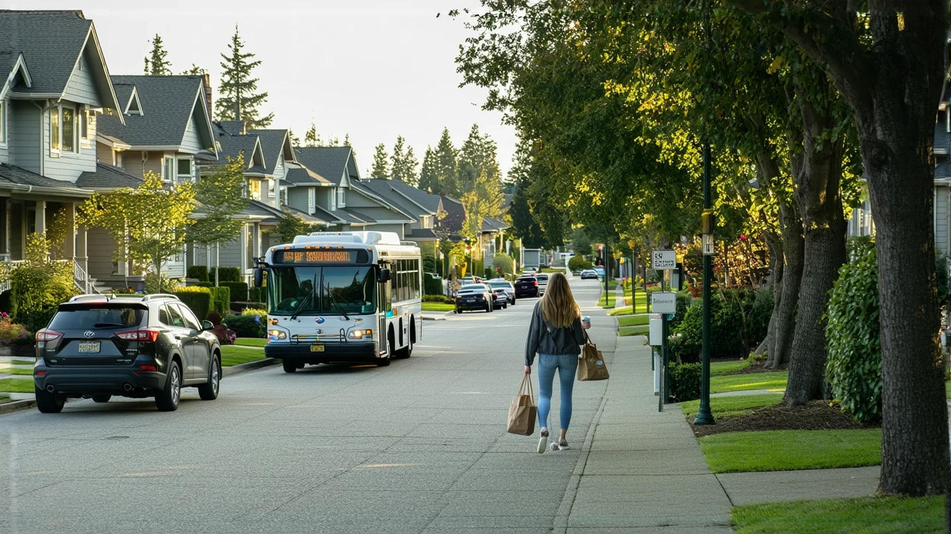
How People Get Around Kirkland
Kirkland’s transportation landscape reflects its evolution from a small lakeside town into a bustling suburban city with urban pockets. Most residents drive. That’s the baseline. But within that car-oriented framework, there are neighborhoods—particularly closer to the downtown waterfront and along certain commercial corridors—where walking, biking, and occasional bus use become viable for specific trips. The pedestrian-to-road ratio in Kirkland exceeds typical suburban norms in these areas, and bike infrastructure is notably present, with dedicated lanes and paths woven through parts of the city.
What newcomers often misunderstand is that Kirkland’s walkability is localized, not citywide. You can live in a highly walkable pocket near downtown or Totem Lake and handle errands on foot or by bike, but step outside those zones and car dependence returns quickly. The city’s geography—hilly terrain, spread-out commercial nodes, and residential neighborhoods that prioritize privacy over density—means that even short trips can require a vehicle if you’re not strategically located.
Commuters heading into Seattle or Bellevue have options, but those options narrow quickly if your destination isn’t along a major transit corridor or if your schedule doesn’t align with peak service hours. For families managing school drop-offs, weekend activities, or multi-stop errands, driving remains the default mode.
Public Transit Availability in Kirkland
Public transit in Kirkland often centers around systems such as King County Metro, which provides bus service connecting the city to Seattle, Bellevue, Redmond, and other Eastside communities. There is no light rail or commuter rail service within Kirkland itself, so all transit access is bus-based. This matters because it shapes frequency, coverage, and the types of trips transit can realistically support.
Bus service works best along major corridors—routes that connect downtown Kirkland to the University District, downtown Seattle, or Bellevue’s employment centers. If you live near one of these routes and work in a transit-accessible area, commuting by bus can be practical, especially during weekday peak hours when frequency is higher. But coverage thins out quickly in residential neighborhoods away from arterials, and evening or weekend service is often limited.
Transit in Kirkland is supplemental, not comprehensive. It can handle specific commutes and occasional errands, but it doesn’t eliminate the need for a car for most households. Grocery runs, medical appointments, social visits, and anything requiring flexibility or speed typically require driving. The city’s layout—commercial clusters separated by residential zones—means that even if you live near a bus stop, the places you need to reach may not be.
Driving & Car Dependence Reality
Driving in Kirkland is necessary for most daily life, and the infrastructure reflects that. Parking is generally available, though downtown and waterfront areas can see congestion during peak times and weekends. Residential neighborhoods are built with driveways and garages as standard, and most households own at least one vehicle.
Car dependence here isn’t just about commuting—it’s about errands, healthcare, recreation, and social life. Kirkland’s commercial landscape is corridor-clustered, meaning grocery stores, pharmacies, and services tend to concentrate along a few main roads rather than being evenly distributed. If you don’t live near one of those corridors, even a quick errand becomes a drive. Families, in particular, find that managing school schedules, activities, and weekend plans without a car is impractical.
The tradeoff is predictability and control. Driving gives you flexibility to move on your own schedule, handle multi-stop trips efficiently, and reach destinations that transit doesn’t serve. But it also means exposure to gas prices, maintenance costs, insurance, and parking constraints. In Kirkland, that exposure is the price of mobility for most residents.
Commuting Patterns & Daily Mobility
Commuting from Kirkland typically means heading west into Seattle or south into Bellevue, though some residents work locally or remotely. The structure of the commute varies widely depending on job location, schedule flexibility, and household logistics. Single-job commuters with fixed schedules and transit-accessible workplaces can often make bus service work, especially if they live near a frequent route. But anyone managing multiple stops, irregular hours, or destinations outside the core transit network will default to driving.
Daily mobility in Kirkland is shaped by the city’s layout. Errands are often multi-stop affairs—grocery store, pharmacy, dry cleaner, school pickup—and those stops are rarely walkable from one another. Even in the most walkable neighborhoods, comprehensive errands usually require a car. The city’s integrated park access and water features make it appealing for recreation, but reaching trailheads, beaches, or sports facilities almost always means driving.
Proximity matters. Residents who live close to their workplace, whether in Kirkland or a neighboring city, absorb less commute friction and have more flexibility in how they get around. Those commuting longer distances or crossing the lake daily face more exposure to traffic variability, transit delays, and time loss.
Who Transit Works For — and Who It Doesn’t
Public transit in Kirkland fits a specific profile: renters or owners in walkable pockets near downtown or Totem Lake, single commuters heading to Seattle’s core or Bellevue, and individuals with flexible schedules who can adapt to bus timing. If your daily routine is simple—home to work, work to home, with occasional errands—and your destinations align with transit routes, you can reduce car dependence significantly.
Transit doesn’t work well for families managing complex logistics, residents in peripheral neighborhoods, or anyone whose schedule demands evening or weekend mobility. It also struggles with trips that require carrying heavy loads, making multiple stops, or reaching destinations outside the main corridors. The city’s bike infrastructure helps fill some gaps, particularly for short trips within walkable zones, but it doesn’t replace the need for a car for most households.
The fit comes down to geography and routine. Core neighborhoods with high pedestrian density and bus access offer the most transit viability. Outer neighborhoods, even those with good bike infrastructure, still require a car for comprehensive daily life.
Transportation Tradeoffs in Kirkland
Choosing between transit and driving in Kirkland isn’t about cost alone—it’s about predictability, control, and exposure. Transit offers lower direct costs and eliminates parking hassles, but it requires schedule flexibility, limits spontaneity, and works only for specific routes. Driving offers control, speed, and comprehensive access, but it means absorbing fuel volatility, maintenance, insurance, and the friction of traffic and parking.
For most households, the tradeoff tilts toward driving because the city’s structure demands it. Even residents who use transit for commuting often keep a car for errands, weekends, and contingencies. The question isn’t whether to own a car—it’s how much you’ll use it and whether you can structure your life to minimize dependence.
Walkable pockets and bike infrastructure reduce some pressure, particularly for residents who prioritize proximity and are willing to trade space or housing cost for mobility convenience. But those pockets are limited, and competition for housing in them is high.
FAQs About Transportation in Kirkland (2026)
Is public transit usable for daily commuting in Kirkland?
Public transit can work for daily commuting if you live near a frequent bus route and your workplace is in a transit-accessible area like downtown Seattle or Bellevue. Service is bus-only, so frequency and coverage are more limited than in cities with rail. Evening and weekend service is lighter, which affects flexibility.
Do most people in Kirkland rely on a car?
Yes. Most households in Kirkland own and regularly use a car. The city’s layout, errands structure, and limited transit coverage make driving the default mode for comprehensive mobility, even for residents who occasionally use transit or bike.
Which areas of Kirkland are easiest to live in without a car?
Downtown Kirkland and areas near Totem Lake offer the most walkability and transit access. These neighborhoods have higher pedestrian infrastructure density, proximity to bus routes, and clustered errands options. Even there, most residents still keep a car for flexibility.
How does commuting in Kirkland compare to nearby cities?
Kirkland’s commute reality is similar to other Eastside suburbs—car-oriented with bus service to major employment centers. It lacks the rail access that cities closer to Seattle’s core enjoy, but it offers less congestion than denser urban areas. Proximity to the lake and limited bridge crossings can create bottlenecks during peak hours.
Can you bike for errands in Kirkland?
Biking is viable in parts of Kirkland, particularly within walkable pockets where bike infrastructure is notable. The city’s bike-to-road ratio exceeds typical suburban levels in certain areas, and dedicated lanes make short trips safer. But hills, distance between commercial nodes, and weather limit year-round biking for most residents.
How Transportation Fits Into the Cost of Living in Kirkland
Transportation in Kirkland is a structural factor, not just a budget line. How you get around shapes where you can live, how much time you spend commuting, and how much flexibility you have in daily life. Car dependence means ongoing exposure to fuel prices, maintenance, and insurance, but it also means control and access that transit can’t fully replace in this city.
For a clearer picture of where money goes each month, including how transportation fits alongside housing, utilities, and other essentials, the Monthly Budget article offers numeric context and household-specific breakdowns. Understanding transportation costs in isolation misses the tradeoffs—proximity can reduce commute time and fuel use but often comes with higher rent or home prices. Living farther out may lower housing costs but increases time and transportation exposure.
The key is recognizing that transportation in Kirkland isn’t optional for most households—it’s foundational. The city’s layout, transit limitations, and errands structure mean that mobility decisions ripple through every other part of your budget and daily routine. Choose your neighborhood with commute, errands, and access in mind, and you’ll reduce friction. Ignore those factors, and you’ll absorb the cost in time, money, and flexibility.
How this article was built: In addition to public economic data, this article incorporates location-based experiential signals derived from anonymized geographic patterns—such as access density, walkability, and land-use mix—to reflect how day-to-day living actually feels in Kirkland, WA.