How People Get Around Irving
Understanding transportation options in Irving means recognizing that this city operates on two tracks: a car-first suburban framework punctuated by transit-accessible corridors. Most residents drive most of the time, but Irving’s infrastructure includes rail service and pockets of walkable density that create genuine alternatives for households positioned to use them. Newcomers often assume Irving is either fully car-dependent or fully transit-served — the reality is more textured. Where you live, where you work, and how you structure daily errands determine whether transit becomes a practical tool or a theoretical option you rarely touch.
Irving’s layout reflects decades of suburban growth around major employment centers and highway corridors. The pedestrian-to-road ratio exceeds typical suburban thresholds in certain areas, and mixed-use development brings residential and commercial land use into proximity in select neighborhoods. But these walkable pockets don’t blanket the city. Between them lie stretches of single-use residential zones, wide arterials, and commercial strips designed around parking lots. The result is a mobility environment where your block matters more than the city average.
With 32.7% of workers facing long commutes and only 4.8% working from home, most Irving households absorb regular commute exposure. That exposure plays out differently depending on whether you’re near a rail stop or several miles from the nearest station. The question isn’t whether Irving has transit — it does. The question is whether transit aligns with your specific geography and routine.
Public Transit Availability in Irving
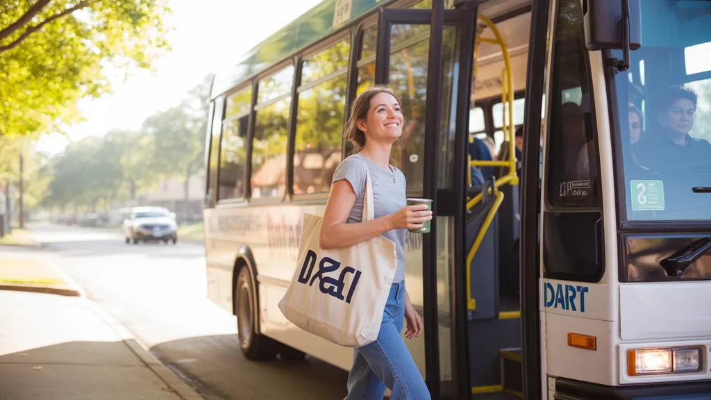
Public transit in Irving often centers around systems such as DART (Dallas Area Rapid Transit), which provides rail service connecting Irving to Dallas and surrounding areas. Rail presence is confirmed and represents the backbone of Irving’s transit infrastructure. Bus service also operates, though coverage and frequency vary significantly by neighborhood. Transit works best along established corridors where density, employment centers, and residential areas converge. In these zones, rail stations anchor access, and bus routes provide supplemental connections.
Outside these corridors, transit thins quickly. Peripheral neighborhoods, newer subdivisions, and low-density residential areas see limited service. Late-night and weekend coverage tends to be sparse even in better-served areas. For households whose daily destinations don’t align with rail routes or major bus corridors, transit becomes impractical not because it doesn’t exist, but because the time cost and transfer burden outweigh the benefit.
Irving’s transit infrastructure reflects its role as a commuter city within a larger metro system. It’s designed to move people between Irving and Dallas, and between Irving’s own employment hubs and residential areas. It’s not designed to serve every block or replace car ownership for most households. Residents near rail stops gain real optionality. Residents several miles away face a different calculus.
Driving & Car Dependence Reality
Driving remains the dominant mode in Irving because the city’s geography, land use, and daily errands infrastructure assume it. Grocery stores, schools, medical offices, and retail clusters are distributed across the city in ways that make multi-stop trips by transit difficult or impossible. Even in walkable pockets, households often need a car for errands that fall outside their immediate radius.
Parking is generally abundant and free in most contexts — residential complexes, shopping centers, and employment sites provide dedicated lots. This reduces one friction point common in denser cities, but it also reinforces car dependence by making driving the path of least resistance. Streets are wide, traffic flows efficiently outside peak hours, and highway access is strong. For households comfortable with driving, Irving’s layout offers convenience and predictability.
Car dependence isn’t a failure of planning; it’s the intended structure. The tradeoff is exposure to fuel prices, maintenance costs, insurance, and the time burden of driving itself. With gas at $3.61 per gallon, households that drive daily feel price swings more acutely than those who can substitute transit for some trips. But substitution requires proximity to transit and destinations that align with transit routes — conditions that don’t apply citywide.
Commuting Patterns & Daily Mobility
Commuting in Irving typically involves either a single-destination trip to a Dallas office or employment center, or a multi-stop routine that includes school drop-offs, errands, and split shifts. The average commute runs 23 minutes, which is manageable but not negligible. That figure masks variation: workers commuting by rail from transit-adjacent neighborhoods may see shorter, more predictable times, while those driving from peripheral areas during peak hours absorb congestion and variability.
Long commutes affect nearly a third of workers, suggesting that many Irving residents either work in distant parts of the metro or face routes that don’t benefit from direct highway access. For these households, commute time becomes a daily fixed cost that shapes housing decisions, childcare logistics, and work-life balance. Proximity to employment or transit access can reduce this burden, but only if the housing stock and price points align.
Daily mobility extends beyond the work commute. Households manage grocery runs, medical appointments, school activities, and social trips. In corridor-clustered areas where food and grocery options concentrate along commercial strips, some of these errands become walkable or bikeable. In lower-density zones, every trip defaults to driving. The structure of your routine — single-stop vs multi-stop, flexible hours vs fixed schedule — determines how much friction you encounter and whether transit can realistically participate.
Who Transit Works For — and Who It Doesn’t
Transit works best for Irving residents who live near rail stations, commute to destinations along the DART rail network, and maintain routines that don’t require frequent multi-stop trips. Renters in transit-adjacent apartments, single workers commuting to Dallas, and households willing to structure errands around walkable corridors benefit most. For these groups, transit reduces driving frequency, lowers fuel exposure, and offers predictable commute times that don’t fluctuate with traffic.
Transit becomes impractical for households in peripheral neighborhoods, families managing school runs and activity schedules, and workers whose job sites sit outside transit corridors. Parents coordinating pickups, residents working non-standard hours, and households that rely on bulk shopping or frequent errands face structural barriers that transit can’t overcome. The issue isn’t willingness — it’s geometry and schedule alignment.
Homeowners in established single-family neighborhoods often find themselves outside the transit-viable zone even if they’d prefer the option. The city’s walkable pockets and rail-adjacent density clusters tend to feature rental stock and smaller housing formats. Families seeking yards, space, and ownership typically trade transit access for those priorities. The tradeoff is rarely explicit, but it’s embedded in where different housing types locate.
How this article was built: In addition to public economic data, this article incorporates location-based experiential signals derived from anonymized geographic patterns—such as access density, walkability, and land-use mix—to reflect how day-to-day living actually feels in Irving, TX.
Transportation Tradeoffs in Irving
Choosing between transit and driving in Irving isn’t about which mode is objectively better — it’s about which aligns with your household’s geography, routine, and priorities. Driving offers flexibility, control, and the ability to manage complex schedules. It absorbs you into the city’s dominant infrastructure and eliminates transfer friction. The cost is ongoing fuel exposure, maintenance, insurance, and the time spent behind the wheel. For households that value spontaneity, multi-stop efficiency, or live outside transit zones, driving remains the only practical option.
Transit offers predictability, lower per-trip cost exposure, and freedom from parking and traffic stress. It works when your origins and destinations align with rail corridors and your schedule tolerates fixed routes and transfer times. The tradeoff is reduced flexibility and longer trip times for errands that fall outside the network. For single-destination commuters near rail, transit can reduce both cost and cognitive load. For everyone else, it’s a supplement at best.
The real tradeoff isn’t transit vs driving in isolation — it’s where money goes across housing, transportation, and time. Living near transit often means higher rent or smaller units. Living farther out reduces housing costs but increases driving dependence and commute time. Neither choice is wrong, but each carries a different cost structure and lifestyle implication. Understanding how transportation shapes your day-to-day costs and routines helps you choose the tradeoff that fits.
FAQs About Transportation in Irving (2026)
Is public transit usable for daily commuting in Irving?
Yes, if you live near a rail station and commute to a destination along the DART network. Rail service provides reliable, predictable access to Dallas and other metro areas. For residents outside transit corridors or those with multi-stop routines, transit becomes less practical. Usability depends heavily on where you live and where you work.
Do most people in Irving rely on a car?
Yes. The majority of Irving residents drive for daily errands, commuting, and household logistics. The city’s layout, land use, and infrastructure assume car access. Transit serves as a viable alternative for a subset of residents, but it doesn’t replace car ownership for most households.
Which areas of Irving are easiest to live in without a car?
Areas near rail stations and within walkable pockets where residential and commercial land use mix offer the best car-free or car-light viability. These neighborhoods tend to feature higher pedestrian infrastructure density and proximity to grocery, dining, and services. Peripheral and low-density residential zones require a car for practical daily living.
How does commuting in Irving compare to nearby cities?
Irving’s average commute of 23 minutes sits in a manageable range, but nearly a third of workers face long commutes. Proximity to Dallas and highway access benefit some residents, while others absorb congestion and distance. Compared to more transit-dense cities, Irving leans car-dependent. Compared to outer suburbs, it offers stronger rail access for those positioned to use it.
Can you bike for transportation in Irving?
Cycling infrastructure exists in pockets, with bike-to-road ratios in the medium band in certain areas. Biking works best for short trips within neighborhoods or along specific corridors. It’s not a citywide solution, and many routes lack protected infrastructure. Biking serves as a supplement for some residents but doesn’t replace driving or transit for most trips.
How Transportation Fits Into the Cost of Living in Irving
Transportation isn’t just a line item — it’s a structural factor that shapes housing pressure, time allocation, and household flexibility. Living near transit may raise rent but reduce fuel costs and commute unpredictability. Living farther out lowers housing costs but increases driving dependence and time spent commuting. Both paths work, but they produce different cost profiles and daily rhythms.
Irving’s mixed mobility landscape means you have real choices, but those choices require geographic alignment. If your job, housing budget, and household needs all point toward a transit-accessible corridor, you can reduce car dependence meaningfully. If any of those factors pull you toward peripheral neighborhoods, you’ll absorb the costs and benefits of driving. The key is recognizing which pattern fits your situation and planning accordingly.
For a fuller picture of how transportation costs interact with housing, utilities, and other expenses, see Your Monthly Budget in Irving: Where It Breaks. Understanding the whole cost structure helps you make tradeoffs that align with your priorities rather than assumptions about how transportation “should” work.