The 6:47 a.m. Tri-Rail pulls into Hollywood Station with a low hydraulic hiss, and Maria swipes her card without breaking stride. She’s headed to a consulting gig in downtown Miami, laptop bag slung across her shoulder, coffee still warm. The train fills quickly—students heading to FIU, healthcare workers bound for Jackson Memorial, a handful of airport employees starting early shifts. By the time the doors close, she’s settled into a window seat, already answering emails. No traffic. No parking hunt. Just 40 minutes of reclaimed time before the workday officially begins.
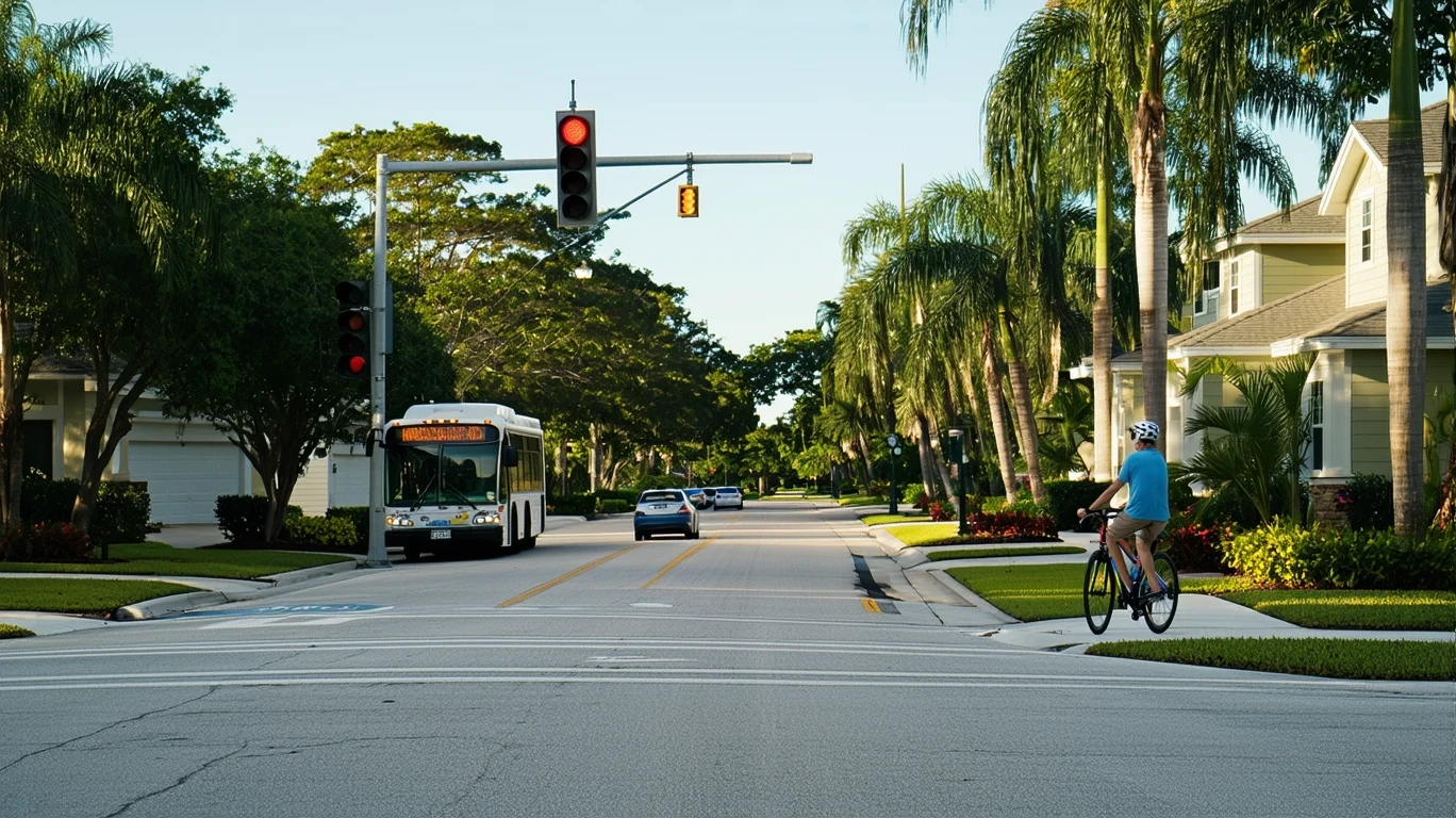
Transportation options in Hollywood don’t fit a single template. This is a city where rail service exists and walkable pockets emerge along certain corridors, yet most residents still rely on cars for the majority of their daily movement. The infrastructure supports multiple mobility patterns, but the dominant one remains car-first. What separates Hollywood from purely suburban sprawl is the presence of real alternatives in specific zones—alternatives that work exceptionally well for some households and barely register for others.
Understanding how people actually get around here requires looking past broad averages and focusing on geography, density, and the daily logistics that shape commute decisions. Hollywood’s transportation reality is layered: rail-accessible cores coexist with car-dependent residential streets, and the difference between the two can be measured in blocks, not miles.
How People Get Around Hollywood
Hollywood’s mobility structure reflects its position as a mid-density coastal city within the broader Miami-Fort Lauderdale metro. The city exhibits more vertical building character than typical Florida suburbs, and mixed land use is present throughout much of the core. These structural features create pockets where walking, transit, and cycling become viable for specific trip types—but they don’t eliminate the need for a car across most of the city.
The pedestrian-to-road ratio in Hollywood exceeds thresholds typically associated with car-only environments, meaning that sidewalks, crosswalks, and pedestrian pathways are woven into the street network more densely than in purely auto-oriented suburbs. This doesn’t mean the entire city is walkable in the Portland or Boston sense, but it does mean that certain neighborhoods support foot traffic as a practical mode for errands, dining, and short trips.
Cycling infrastructure exists in pockets, with bike-to-road ratios sitting in a moderate band. You’ll find bike lanes and paths in some corridors, but the network isn’t comprehensive or continuous. For residents who live and work within a narrow geographic zone, biking can supplement other modes. For most, it remains recreational rather than utilitarian.
What newcomers often misunderstand is that Hollywood’s transportation options are highly localized. Living near the Broadwalk, downtown Hollywood, or along a rail corridor opens up mobility choices that simply don’t exist in the western residential zones. The city’s layout rewards proximity to specific nodes, and penalizes distance from them.
Public Transit Availability in Hollywood
Public transit in Hollywood often centers around systems such as Tri-Rail and Broward County Transit, though coverage and service patterns vary significantly by area. Rail service is present in the city, which distinguishes Hollywood from many Florida communities where bus-only networks define the transit landscape. The existence of rail creates a fundamentally different commute option for residents within reach of a station—one that bypasses highway congestion entirely and connects directly to employment centers in Miami and Fort Lauderdale.
Transit works best along corridors where density, mixed-use development, and pedestrian infrastructure converge. In these zones, residents can combine walking with rail or bus service to complete a full trip without needing a car. Grocery density in Hollywood exceeds high thresholds in certain areas, and food establishment density sits in a moderate range, meaning that some neighborhoods support a transit-oriented lifestyle where daily errands remain accessible on foot or via a short bus connection.
Where transit falls short is in the lower-density residential neighborhoods that stretch west and north from the urban core. These areas were designed around the car, and retrofitting them with effective transit service is structurally difficult. Bus routes may exist, but frequencies, coverage gaps, and indirect routing make them impractical for time-sensitive trips. Late-night and weekend service is limited across most of the network, which constrains transit viability for shift workers, service industry employees, and anyone whose schedule doesn’t align with peak commute windows.
The role transit plays in Hollywood is supplemental for most residents and primary for a smaller subset. It’s a real option, not a theoretical one—but it’s not a citywide solution.
Driving & Car Dependence Reality
Despite the presence of rail and walkable pockets, driving remains the default mode for most households in Hollywood. The city’s layout, the distribution of jobs across the metro, and the practical demands of multi-stop trips all reinforce car dependence. Families managing school drop-offs, grocery runs, and weekend activities find that transit and walking can handle some trips but rarely all of them.
Parking availability varies by neighborhood. In the densest parts of downtown Hollywood and near the beach, street parking can be competitive, and some residential buildings rely on structured or assigned parking. In the western neighborhoods, driveways and garages are standard, and parking friction is minimal. This geographic split mirrors the broader mobility divide: where density increases, car ownership becomes more optional; where density thins, it becomes non-negotiable.
Commute flexibility is one of the strongest arguments for car ownership in Hollywood. The average commute in the city is 30 minutes, but nearly half of all workers (48.4%) face longer commutes, suggesting that many residents travel well beyond Hollywood’s borders for work. For these commuters, transit may cover the primary leg of the trip, but the first and last mile often require a car, rideshare, or a complex transfer. Driving offers directness, schedule control, and the ability to chain trips—advantages that matter more as household logistics grow more complex.
Sprawl is a factor, but not in the extreme form seen in Sun Belt metros like Phoenix or Houston. Hollywood sits within a relatively compact metro footprint, but jobs, services, and social destinations are still dispersed enough that car-free living requires intentional trade-offs in housing location, employment options, and daily convenience.
Commuting Patterns & Daily Mobility
Commuting in Hollywood breaks into three broad patterns: single-destination commuters who travel to a fixed workplace, multi-stop commuters who chain errands or job sites, and flexible-schedule workers who avoid peak congestion or work from home part of the week. Each group experiences the city’s transportation infrastructure differently.
Single-destination commuters—especially those traveling to downtown Miami, Fort Lauderdale, or West Palm Beach—benefit most from rail access. A direct train connection eliminates the variability of I-95 traffic and converts commute time into usable work time. For this group, proximity to a Tri-Rail station can be the single most valuable transportation asset in Hollywood.
Multi-stop commuters face a harder calculus. If the day includes dropping kids at school, stopping at a client site, picking up supplies, and returning home, transit rarely covers the full chain. These households rely on cars not because transit doesn’t exist, but because it doesn’t flex to accommodate non-linear trips.
Flexible-schedule workers—about 12% of Hollywood’s workforce works from home—often use a hybrid approach. They may drive on days when meetings or deadlines require speed and predictability, and take transit or bike on days when schedule pressure is lower. This group benefits from Hollywood’s mixed infrastructure, using each mode where it offers the greatest advantage.
The 30-minute average commute in Hollywood reflects a metro-wide pattern where most workers travel between 20 and 45 minutes, depending on mode and destination. The high percentage of long commutes (48.4%) suggests that a significant share of residents work in job centers that aren’t well-served by local transit, reinforcing car dependence even in households that might otherwise prefer alternatives.
Who Transit Works For — and Who It Doesn’t
Transit in Hollywood works best for renters living in the urban core or near rail stations, especially those commuting to a single fixed destination within the metro. Young professionals, graduate students, and healthcare workers traveling to major hospital systems in Miami find that rail service aligns well with their schedules and destinations. For this group, car ownership shifts from necessity to convenience, and some forgo it entirely.
Transit also works for households willing to trade geographic flexibility for lower transportation costs and reduced commute stress. Living near a station or along a high-frequency bus corridor requires accepting a narrower range of housing options, but it unlocks a different daily rhythm—one where commuting becomes predictable and parking becomes irrelevant.
Transit struggles to serve families with school-age children, especially those managing multiple drop-off and pick-up windows. School bus service exists, but coverage and timing don’t always align with parent work schedules, forcing many families into car dependency regardless of their proximity to transit. Similarly, households with members working non-traditional hours—early mornings, late evenings, or weekends—find that transit service thins or disappears outside peak windows.
Peripheral neighborhoods, particularly those west of I-95, remain functionally car-dependent. These areas lack the density, walkability, and transit frequency that make car-free living practical. Residents in these zones may use transit occasionally for specific trips, but daily mobility revolves around personal vehicles.
The fit question isn’t about whether transit exists in Hollywood—it does. The question is whether a household’s daily logistics, work location, and housing options align with the corridors where transit actually functions as a primary mode.
Transportation Tradeoffs in Hollywood
Choosing between transit and driving in Hollywood isn’t a binary decision for most households—it’s a question of which mode handles which trips, and what trade-offs each requires.
Transit offers predictability on congested corridors, eliminates parking friction, and converts commute time into productive or restful time. It works best when trips are linear, destinations are fixed, and schedules align with service windows. The cost structure is different, too—transit reduces exposure to fuel price swings, parking fees, and vehicle depreciation, though it introduces time costs on routes with transfers or indirect routing.
Driving offers flexibility, speed, and the ability to handle complex trip chains without coordination. It works best when destinations are dispersed, schedules are variable, or household logistics involve multiple stops. The cost structure is higher and more variable, with exposure to fuel prices, maintenance, insurance, and parking, but it delivers control and convenience that transit can’t match for non-linear trips.
For households near rail stations, the tradeoff often tips toward transit for work commutes and driving for everything else. For households in peripheral zones, the tradeoff tips toward driving for nearly all trips, with transit serving as an occasional backup or a way to avoid downtown parking.
The transportation landscape in Hollywood rewards households that can align their housing location with their primary commute destination. Proximity to a rail station or a high-frequency bus corridor doesn’t eliminate the need for a car, but it reduces how often that car is necessary—and that reduction translates into lower stress, lower costs, and more predictable daily routines.
FAQs About Transportation in Hollywood (2026)
Is public transit usable for daily commuting in Hollywood?
Yes, but viability depends heavily on where you live and where you work. Rail service connects Hollywood to major employment centers in Miami and Fort Lauderdale, making transit a strong option for single-destination commuters living near a station. For residents in peripheral neighborhoods or those with multi-stop daily routines, transit becomes less practical, and car dependence increases.
Do most people in Hollywood rely on a car?
Yes. While rail service exists and walkable pockets are present, the majority of households in Hollywood depend on cars for daily mobility. The city’s layout, the distribution of jobs across the metro, and the practical demands of errands, school runs, and non-work trips all reinforce car ownership as the dominant mode.
Which areas of Hollywood are easiest to live in without a car?
Downtown Hollywood, neighborhoods near the Broadwalk, and areas within walking distance of a Tri-Rail station offer the most viable car-free or car-light lifestyles. These zones combine pedestrian infrastructure, transit access, and higher grocery and food establishment density, making it possible to handle many daily needs without driving.
How does commuting in Hollywood compare to nearby cities?
Hollywood sits in the middle of the regional commute spectrum. It offers better transit access than purely suburban communities like Pembroke Pines or Miramar, thanks to rail service and denser urban cores. However, it doesn’t match the transit frequency or coverage of downtown Miami or Fort Lauderdale. Commute times in Hollywood average 30 minutes, with a significant share of workers facing longer trips that extend beyond local transit service areas.
Can you bike for transportation in Hollywood?
Biking is viable in certain corridors where infrastructure exists, but the network isn’t comprehensive. Cycling works best for short trips within a limited geographic zone, particularly in areas with mixed-use development and lower traffic speeds. For most residents, biking remains a recreational activity rather than a primary transportation mode, though it can supplement transit or driving for specific trips.
How Transportation Fits Into the Cost of Living in Hollywood
Transportation isn’t just a line item in a household budget—it’s a structural force that shapes housing choices, time allocation, and daily flexibility. In Hollywood, where mobility options vary sharply by neighborhood, the decision of where to live often determines how much time and money a household will spend getting around.
Households near rail stations or within walkable cores can reduce transportation costs by relying more on transit, biking, or walking for daily trips. This proximity often comes with higher rent or home prices, but the trade-off can pencil out when car ownership shifts from necessity to occasional use. For families or multi-worker households, the calculus is more complex—saving on one car may be possible, but eliminating all vehicles rarely works unless housing, work, and school align within a narrow geographic zone.
For residents in car-dependent neighborhoods, transportation costs are higher and less flexible. Fuel prices, insurance, maintenance, and parking all add up, and these costs don’t scale down easily when budgets tighten. The exposure to volatility is greater, and the time cost of commuting—especially for those in the 48.4% facing long commutes—compounds the financial burden.
Hollywood’s transportation landscape offers real choices, but those choices are geographically constrained. The city rewards proximity to transit and density, and penalizes distance from both. Understanding how mobility options map onto daily life is essential for making housing decisions that align with both financial realities and lifestyle priorities.
How this article was built: In addition to public economic data, this article incorporates location-based experiential signals derived from anonymized geographic patterns—such as access density, walkability, and land-use mix—to reflect how day-to-day living actually feels in Hollywood, FL.
—