“I take Caltrain to work three days a week, and honestly, it’s the only reason I don’t lose my mind in traffic,” says Marcus, a software engineer who’s lived in Palo Alto for four years. “But if I need to pick up groceries after work or get my kid from practice? I’m back in the car. It’s a hybrid life here.”
That hybrid reality defines how most people navigate Palo Alto. This isn’t a city where you choose transit or driving and stick with it. It’s a place where your transportation strategy depends heavily on where you live, where you work, and what your daily routine actually looks like. Understanding how people get around here—and why certain patterns dominate—matters as much as understanding housing costs or income levels.
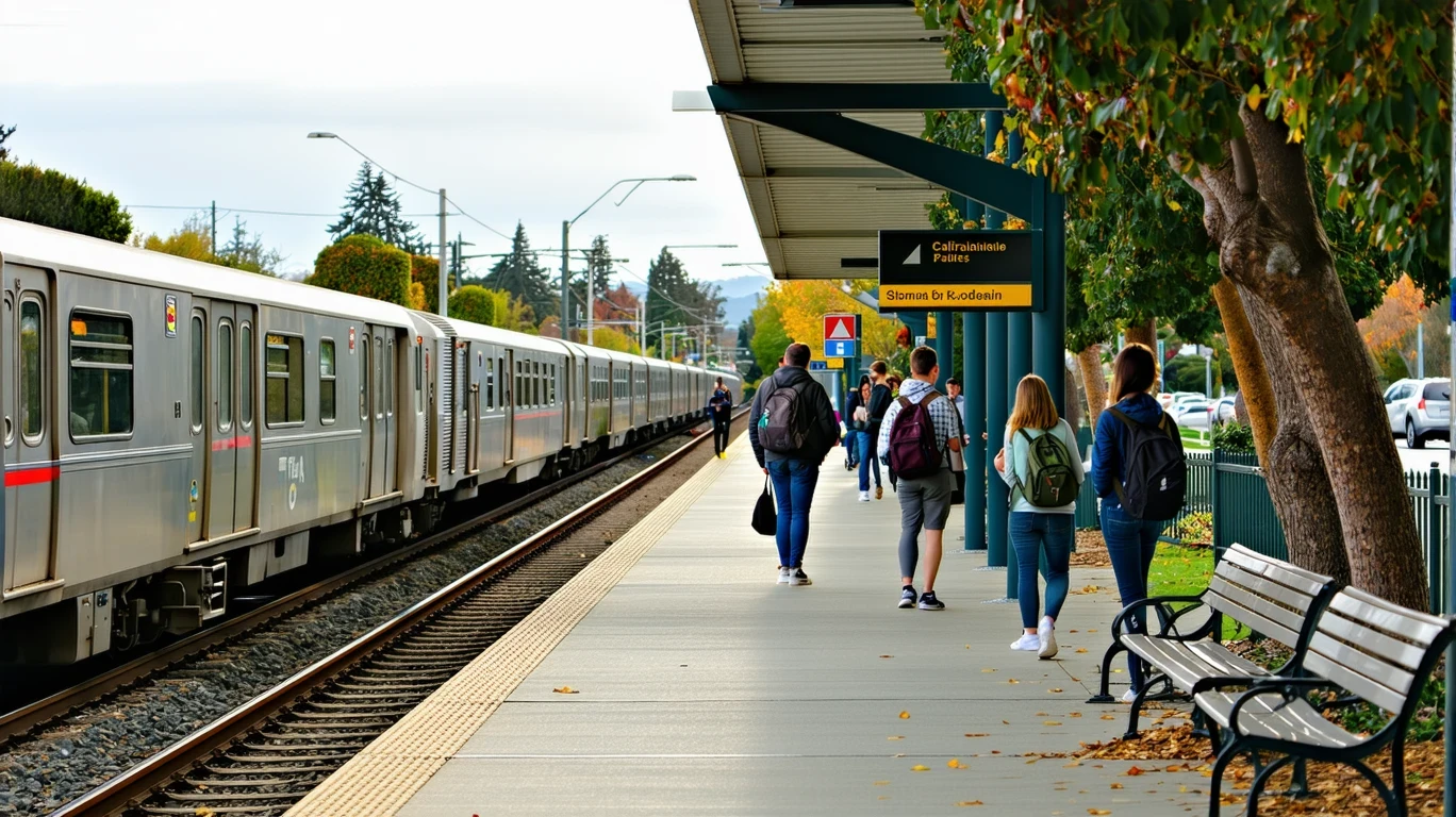
How People Get Around Palo Alto
Palo Alto sits in a geographic sweet spot that creates a layered mobility environment. The city has rail access, substantial pedestrian infrastructure in certain areas, and notable cycling presence throughout parts of town. At the same time, it’s embedded in a region where car ownership remains the default for most households.
What newcomers often misunderstand is that transportation options in Palo Alto aren’t evenly distributed across the city. Some neighborhoods offer genuine walkability, bike-friendly streets, and proximity to transit stations. Others are quieter, more residential, and require a car for nearly everything. The dominant pattern isn’t car-first or transit-supported—it’s situational. Where you live and where you need to go determine which mode makes sense on any given day.
The city’s pedestrian-to-road ratio exceeds regional benchmarks in pockets, meaning sidewalks, crossings, and pedestrian paths are denser relative to road infrastructure in those areas. Cycling infrastructure is present at levels that support regular bike commuting for those who live and work along the right corridors. But these features don’t blanket the entire city uniformly.
For daily errands, Palo Alto performs well. Food and grocery density exceed thresholds that typically support walkable access, meaning many residents can handle routine shopping on foot or by bike if they live in the right part of town. This reduces the need to drive for every small errand, which changes the texture of daily life compared to more car-dependent suburbs.
Public Transit Availability in Palo Alto
Public transit in Palo Alto often centers around systems such as Caltrain, which provides rail service connecting the Peninsula to San Francisco and San Jose. The presence of rail transit is significant—it offers a structured, predictable commute option for those working along the corridor or in major employment centers to the north and south.
Transit tends to work best for residents living within reasonable distance of stations and working in locations well-served by the rail line. For these households, the train becomes a viable primary commute mode, reducing reliance on driving during peak hours and avoiding the stress of highway congestion.
Where transit falls short is in coverage beyond the rail corridor. Palo Alto is not a dense urban core with comprehensive bus networks running every ten minutes. Late-hour service, cross-town trips, and routes that don’t align with the main rail spine often require a car. Families managing multiple stops—school drop-offs, after-school pickups, weekend activities—find transit impractical for anything beyond a single-destination commute.
The city’s layout and the regional transit structure mean that transit works well for a specific use case: the solo commuter traveling along established corridors during standard hours. It works less well for complex household logistics, off-peak travel, or trips that require flexibility.
Driving & Car Dependence Reality
Despite the presence of rail and cycling infrastructure, driving remains necessary for most residents most of the time. Palo Alto’s development pattern includes both walkable cores and quieter residential areas that are further from services and transit. Even in walkable neighborhoods, households typically own at least one car for trips that don’t fit neatly into a transit schedule.
Car dependence here isn’t about sprawl in the traditional sense—it’s about the region’s geography and the distribution of jobs, schools, and services. Commutes often involve crossing city boundaries, and regional transit doesn’t cover every employment center or errand destination. Parking is part of the landscape, but it’s managed differently depending on where you are. Near downtown and commercial districts, parking can be limited and requires planning. In residential areas, most homes have driveways or garages, reducing day-to-day friction.
The tradeoff is control and flexibility. A car lets you manage multi-stop days, handle last-minute changes, and access parts of the region that transit doesn’t serve well. The cost is exposure to traffic, fuel prices (currently $5.89 per gallon in the area), and the ongoing expense of vehicle ownership and maintenance.
Commuting Patterns & Daily Mobility
Commuting in Palo Alto reflects the city’s role as both a residential community and an employment hub. The average commute is 23 minutes, which is relatively short compared to more distant suburbs but still requires planning. About 6.0% of workers work from home, a figure that reflects the city’s tech-sector presence but also shows that the majority of residents still commute regularly.
Roughly 27.8% of workers face long commutes, meaning a significant share of residents are traveling well beyond Palo Alto’s borders for work. These longer commutes often involve highway driving or multi-leg transit trips, and they shape daily schedules in ways that affect household logistics, childcare timing, and evening routines.
For those working locally or along the Caltrain corridor, commutes can be straightforward and predictable. For those working in more dispersed locations—South Bay campuses, East Bay offices, or San Francisco neighborhoods not well-served by rail—the commute becomes a more complex puzzle involving timing, transfers, or simply accepting a longer drive.
Daily mobility isn’t just about the work commute. It’s also about how people chain trips together: dropping kids at school, stopping for groceries, picking up dry cleaning, meeting friends for dinner. Palo Alto’s relatively high grocery and food establishment density means some of these errands can happen on foot or by bike, especially for residents in central areas. But the full daily circuit often still requires a car at some point.
Who Transit Works For — and Who It Doesn’t
Transit in Palo Alto is a good fit for a specific household profile: individuals or couples without complex daily logistics, living near a station, working along a rail-served corridor, and comfortable with a structured schedule. For these residents, rail transit offers a real alternative to driving, reducing commute stress and avoiding parking hassles at the destination.
Renters in downtown or near-station neighborhoods often benefit most from transit access. They tend to prioritize walkability and proximity to services, and they’re more likely to structure their lives around a car-light or car-free model. Younger professionals, grad students, and empty-nesters fit this pattern well.
Transit works less well for families with school-age children, especially those managing multiple daily stops. It also struggles to serve residents in peripheral neighborhoods where walking to a station isn’t practical and bus connections are infrequent. Households with two working adults commuting in different directions, or those with jobs requiring a car for work purposes, find transit insufficient as a primary solution.
Homeowners in quieter residential areas typically own cars regardless of transit access. The flexibility and convenience outweigh the potential savings from going car-free, especially when household income levels (median household income in Palo Alto is $214,118 per year) make car ownership financially manageable even if not trivial.
Transportation Tradeoffs in Palo Alto
Choosing between transit and driving in Palo Alto isn’t about finding the cheapest option—it’s about matching your transportation strategy to your daily reality and priorities.
Transit offers predictability. The train runs on a schedule, and once you’re on board, you’re insulated from traffic variability. You can read, work, or simply decompress. For commuters heading to San Francisco or South Bay employment centers, this predictability is valuable. The tradeoff is rigidity. You’re bound to the schedule, and any deviation—a late meeting, an errand after work, a sick kid—requires a backup plan, usually in the form of a car.
Driving offers control and flexibility. You leave when you want, stop where you need to, and adjust on the fly. For households managing complex schedules or living in areas where transit coverage is thin, driving isn’t optional—it’s the only practical mode. The tradeoff is exposure to traffic, parking constraints in some areas, and ongoing vehicle costs.
Many Palo Alto households end up with a hybrid approach: one adult uses transit for a regular commute, while the household maintains a car for everything else. This strategy captures some of the benefits of both modes but requires coordination and still involves the fixed costs of car ownership.
The decision isn’t binary. It’s about understanding which parts of your life can realistically run on transit and which parts require a car, then structuring your housing location and vehicle ownership accordingly.
FAQs About Transportation in Palo Alto (2026)
Is public transit usable for daily commuting in Palo Alto?
Yes, for residents living near rail stations and commuting along corridors served by Caltrain. Rail transit provides a structured, predictable option for reaching San Francisco, Peninsula cities, and parts of the South Bay. It works best for solo commuters with standard schedules and destinations near stations. It’s less practical for multi-stop trips, off-peak travel, or commutes to areas without rail access.
Do most people in Palo Alto rely on a car?
Yes. Even with rail access and walkable pockets, most households own and use cars regularly. The region’s geography, the distribution of jobs and services, and the complexity of daily household logistics make car ownership the norm. Many residents use a hybrid approach—transit for some trips, driving for others—but few go entirely car-free.
Which areas of Palo Alto are easiest to live in without a car?
Neighborhoods near downtown and within walking or biking distance of a Caltrain station offer the most car-light viability. These areas combine transit access with higher density of grocery stores, restaurants, and services, making it possible to handle many daily needs on foot or by bike. Peripheral residential areas are harder to navigate without a car.
How does commuting in Palo Alto compare to nearby cities?
Palo Alto’s average commute of 23 minutes is shorter than more distant suburbs but reflects the city’s central Peninsula location. Residents benefit from proximity to major employment centers, but nearly 28% still face long commutes, often involving travel to San Francisco, the East Bay, or South Bay campuses. Compared to cities further from the region’s core, Palo Alto offers better transit access and shorter average commutes, but it’s not immune to regional traffic patterns.
Can you bike regularly in Palo Alto?
Yes, especially in areas with notable cycling infrastructure. The bike-to-road ratio is high enough to support regular cycling for those living and working along bike-friendly corridors. Palo Alto’s relatively flat terrain and temperate climate (currently 68°F) make biking practical year-round for many residents. However, cycling works best for shorter trips and requires comfort sharing space with cars on some routes.
How Transportation Fits Into the Cost of Living in Palo Alto
Transportation isn’t just a line item—it’s a structural factor that shapes where you can live, how you spend your time, and what tradeoffs you’re willing to accept. In Palo Alto, the presence of rail transit and walkable pockets creates real options for some households, but it doesn’t eliminate the need for most people to own a car.
The decision to rely on transit, drive, or use a hybrid approach affects housing choice. Living near a station often means higher rent or home prices, but it also means reduced commute stress and potentially lower transportation costs if you can go car-light. Living further from transit usually means more space and potentially lower housing costs, but it locks in car dependence and the expenses that come with it.
For a fuller picture of how transportation costs interact with housing, utilities, and other expenses, see Your Monthly Budget in Palo Alto: Where It Breaks.
Understanding how people actually get around Palo Alto—and why certain patterns dominate—helps you make better decisions about where to live, whether to own a car, and how to structure your daily routine. The city offers more transportation flexibility than many suburban communities, but it still requires you to match your strategy to your specific circumstances. The goal isn’t to find the perfect solution—it’s to find the one that fits your life.
How this article was built: In addition to public economic data, this article incorporates location-based experiential signals derived from anonymized geographic patterns—such as access density, walkability, and land-use mix—to reflect how day-to-day living actually feels in Palo Alto, CA.