| Transportation Mode | Coverage Pattern | Typical Role |
|---|---|---|
| Bus Service | Corridor-based | Baseline access for specific routes |
| Personal Vehicle | Citywide | Primary mobility for most households |
| Walking | Pockets with high pedestrian infrastructure | Supplemental for errands in select areas |
| Cycling | Limited corridors | Recreational or short-distance option |
Average commute time: 21 minutes
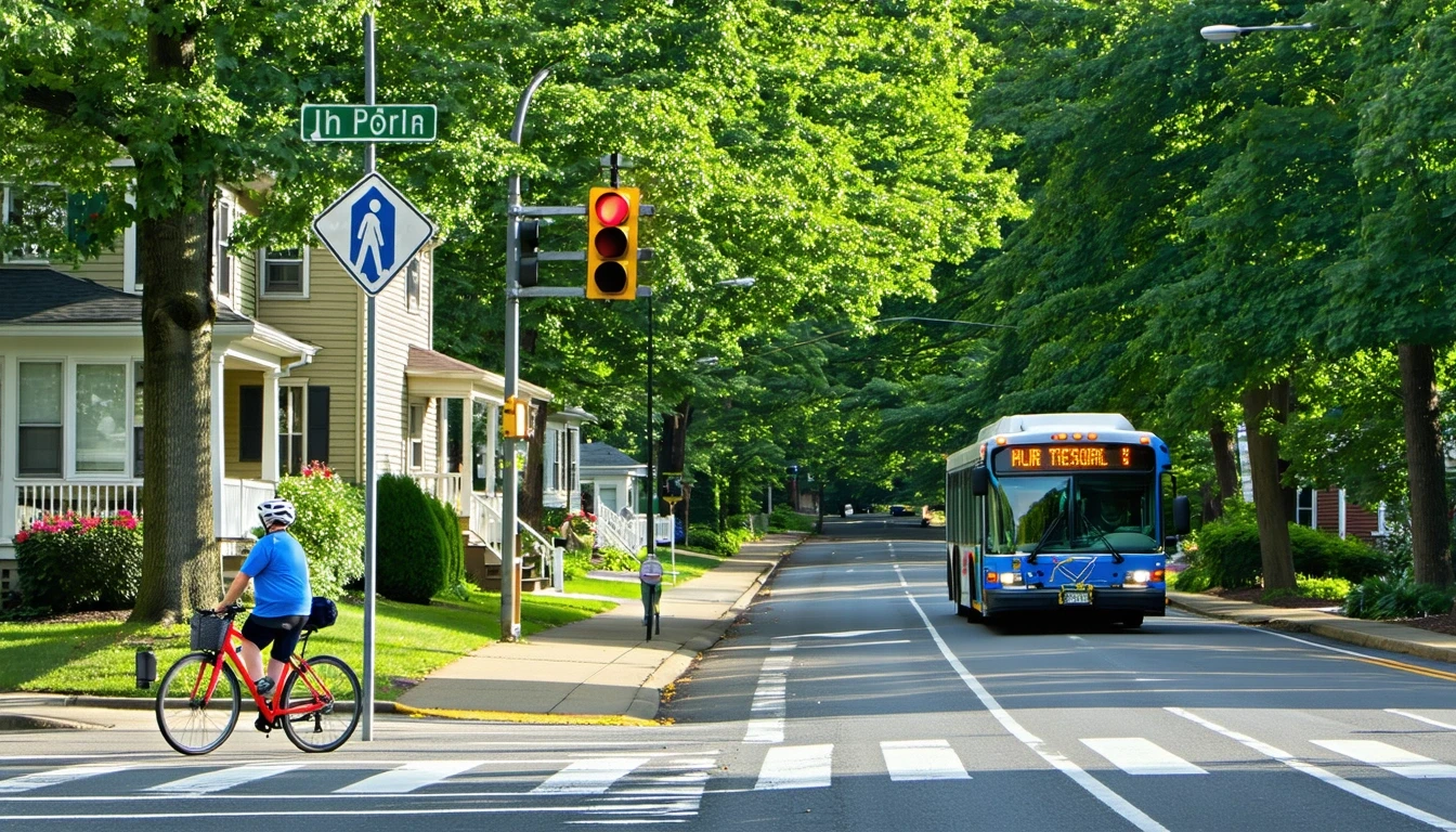
How People Get Around Newington
Transportation options in Newington reflect a suburban structure where personal vehicles dominate daily mobility, but pockets of walkable infrastructure and bus service create alternatives for specific trips and households. The city’s layout—mixed-height buildings, residential neighborhoods interspersed with commercial corridors, and pedestrian infrastructure concentrated in certain areas—shapes how people move through their day. Newcomers often expect either complete car dependence or robust transit coverage; Newington delivers neither extreme. Instead, it offers a middle ground where driving remains the most flexible option, but bus routes and walkable zones provide real alternatives for those whose routines align with where infrastructure exists.
The average commute in Newington takes 21 minutes, a relatively short duration that reflects the city’s position within the Hartford metro area and proximity to regional employment centers. Yet proximity doesn’t automatically translate to transit viability. What matters more is whether your home, workplace, and daily errands fall along corridors where pedestrian paths, bus stops, and commercial density converge. For households situated in these zones, a car may shift from necessity to convenience. For those in quieter residential pockets, the car remains essential regardless of commute distance.
Understanding how transportation works here means recognizing that Newington’s infrastructure supports multiple patterns simultaneously. Some residents walk to grocery stores with high density along commercial strips, catch a bus for work trips, and drive only occasionally. Others find that even short errands require a vehicle because their home sits outside walkable reach of services. The city’s structure doesn’t force a single lifestyle—it rewards those who can align their location and routine with where transit and pedestrian infrastructure actually exist.
Public Transit Availability in Newington
Public transit in Newington centers around bus service, which provides baseline access along specific routes but lacks the frequency, coverage, and rail connectivity that define transit-rich environments. Bus stops are present throughout the city, offering a foundational layer of mobility for residents whose schedules can accommodate fixed routes and timing. This isn’t a system designed for spontaneous trips or last-minute flexibility—it’s infrastructure that works best when your routine aligns with where buses run and when they operate.
Transit tends to function most effectively along commercial corridors where residential density, retail access, and employment destinations cluster. In these zones, a bus route can connect multiple daily needs—commute, errands, appointments—without requiring a car for every trip. But coverage thins quickly in residential areas set back from main roads, and service outside peak hours often becomes sparse enough to make timing a central constraint. For someone working a standard schedule along a bus line, transit can be viable. For someone with irregular hours, multiple stops, or destinations off major routes, the system’s limitations become immediate.
What Newington lacks is rail service, which in other cities provides higher frequency, greater capacity, and more predictable travel times. Without rail, the transit network depends entirely on bus routes that must navigate the same traffic as cars, making reliability vulnerable to congestion and weather. This doesn’t mean transit is unusable—it means transit users need to plan around the system’s constraints rather than expect the system to adapt to their needs.
Driving & Car Dependence Reality
Driving in Newington isn’t just the most common transportation choice—it’s the default mode that the city’s infrastructure assumes. Roads connect every neighborhood, parking is typically available at homes and destinations, and the spatial layout of residential and commercial areas makes multi-stop trips far easier by car than by any other mode. Even in areas with pedestrian infrastructure, the distances between home, work, and errands often stretch beyond comfortable walking range, and bus routes may not connect all three efficiently.
Car dependence here isn’t about preference or lifestyle—it’s a structural reality shaped by how the city developed. Residential streets branch off main corridors, commercial zones cluster rather than distribute evenly, and the density required to support frequent transit or walkable access to all services simply doesn’t exist in most areas. For families managing school drop-offs, grocery runs, and activities across multiple locations, a car provides the flexibility that no other mode can match. For individuals living along a bus route near commercial density, a car may be optional—but that describes a minority of households, not the norm.
Parking pressure remains low compared to denser urban centers, meaning that owning and using a car doesn’t come with the added friction of scarce or expensive parking. This reinforces car dependence by removing one of the typical deterrents. The tradeoff is that households must absorb the full cost structure of vehicle ownership—purchase or lease, insurance, maintenance, fuel—because there’s no realistic way to avoid it for most daily routines.
Commuting Patterns & Daily Mobility
Commuting in Newington typically involves a single-destination trip to a workplace within the Hartford metro area, with the 21-minute average suggesting that many residents work relatively close to home. However, roughly 24% of workers experience longer commutes, indicating that while proximity is common, it’s not universal. The short average also reflects the fact that only 3% of workers operate from home, meaning nearly all employed residents are making regular commute trips rather than eliminating travel entirely.
Daily mobility extends beyond the commute. Households must also navigate errands, and here Newington’s corridor-clustered grocery and food access becomes relevant. High grocery density along certain routes means that residents near these corridors can consolidate errands efficiently, while those farther out face longer trips or multiple stops. The presence of both residential and commercial land use in proximity—confirmed by the city’s mixed-use character—creates opportunities for trip-chaining, where a commute home can include a grocery stop without significant detour. But this only works if your route passes through the right corridors.
For households with multiple earners, school-age children, or caregiving responsibilities, daily mobility becomes a logistics puzzle. A car allows sequential stops, flexible timing, and the ability to respond to last-minute needs. Transit, by contrast, requires advance planning and often forces a choice between efficiency and coverage—you can get to your primary destination, but adding stops or adjusting timing introduces friction that many households can’t absorb.
Who Transit Works For — and Who It Doesn’t
Transit in Newington works best for individuals whose home and workplace both sit along bus routes, who maintain predictable schedules, and who can tolerate the time cost of fixed routing. This often describes renters in corridor-adjacent neighborhoods, single commuters without school or caregiving logistics, and workers whose employers are located near transit stops. For these households, bus service provides a functional baseline that reduces or eliminates the need for daily car use, even if a vehicle remains necessary for other trips.
Transit becomes far less viable for families managing multiple destinations, workers with irregular hours, and residents in quieter residential areas where the nearest bus stop requires a drive or a long walk. The system’s structure—corridor-based, bus-only, with limited off-peak service—means that anyone whose routine doesn’t align with where and when buses run will find themselves defaulting to a car. This isn’t a failure of effort or planning; it’s a mismatch between the infrastructure available and the complexity of the trip pattern required.
Homeowners, especially those in single-family neighborhoods set back from commercial corridors, typically find that transit doesn’t integrate into their daily routine. The walkable pockets that exist in Newington offer pedestrian access to some errands, but they don’t extend citywide, and bus service can’t fully substitute for the flexibility a car provides when managing a household. Renters closer to mixed-use zones have more options, but even then, transit works best as a supplement rather than a replacement.
Transportation Tradeoffs in Newington
Choosing between transit and driving in Newington means weighing predictability against flexibility. A car offers control over timing, routing, and the ability to handle unexpected needs—a sick child, a last-minute errand, a schedule change. Transit offers lower direct operating costs and eliminates the need to manage a vehicle, but it requires surrendering control over timing and accepting the constraints of fixed routes and schedules. For many households, this tradeoff resolves in favor of driving simply because the cost of inflexibility—missed appointments, longer trip times, inability to respond to emergencies—outweighs the cost of owning a car.
There’s also a tradeoff between location and transportation mode. Living near a bus route in a corridor with high grocery density makes transit more viable, but those locations may come with different housing costs, noise levels, or neighborhood characteristics. Living in a quieter residential area offers space and calm but locks in car dependence. Neither choice is objectively better—each reflects a different set of priorities and constraints.
For households trying to minimize transportation exposure, the question isn’t whether to use transit or drive—it’s whether your routine and location allow transit to play any role at all. If the answer is yes, bus service can reduce the frequency of car trips and lower fuel consumption. If the answer is no, the focus shifts to managing driving costs through vehicle choice, trip consolidation, and proximity to work. The infrastructure in Newington supports both patterns, but it doesn’t make them equally accessible to everyone.
FAQs About Transportation in Newington (2026)
Is public transit usable for daily commuting in Newington?
Public transit can support daily commuting for residents whose home and workplace align with bus routes and who maintain predictable schedules. The system works best along commercial corridors where service is more frequent and destinations are accessible. For households with irregular hours, multiple stops, or locations outside bus coverage, transit becomes less practical, and driving remains the more reliable option.
Do most people in Newington rely on a car?
Yes. The city’s layout, residential density, and limited transit coverage make personal vehicles the dominant mode of transportation. While bus service and walkable pockets exist, they serve a minority of trips and households. Most residents depend on a car for commuting, errands, and managing household logistics, especially those living outside corridor zones.
Which areas of Newington are easiest to live in without a car?
Areas near commercial corridors with high pedestrian infrastructure and bus access offer the most viable car-free or car-light living. These zones combine walkable access to groceries and services with transit connections for commuting. Residential neighborhoods set back from main roads typically require a car for daily routines, even if they offer other quality-of-life benefits.
How does commuting in Newington compare to nearby cities?
Newington’s 21-minute average commute is relatively short, reflecting proximity to Hartford-area employment centers. However, commute time alone doesn’t capture transportation reality—what matters more is whether your specific route and schedule align with available transit or require driving. Compared to denser cities with rail access, Newington offers less transit flexibility but also less traffic congestion and parking pressure.
Can you bike for transportation in Newington?
Cycling infrastructure exists in limited areas, with bike-to-road ratios in the medium range indicating some dedicated paths or lanes. Biking works best for short trips within neighborhoods or along specific corridors, but it’s not a citywide solution. Weather, distance, and the need to share roads with cars make cycling more viable as a recreational activity or supplement to driving rather than a primary transportation mode for most households.
How Transportation Fits Into the Cost of Living in Newington
Transportation in Newington functions as a structural cost driver, not just a budget line. Whether you rely on a car, use transit occasionally, or manage a mix of both, your mobility pattern shapes where you can live, how much time you spend traveling, and what flexibility you maintain in daily life. For most households, car ownership is unavoidable, which means absorbing the full cost structure—purchase, insurance, maintenance, and fuel at $4.06 per gallon. For the smaller share of residents who can align their routine with bus routes and walkable corridors, transit offers a way to reduce driving frequency and lower fuel consumption, though it rarely eliminates the need for a vehicle entirely.
The interaction between transportation and housing is direct: living near transit or in a walkable corridor may reduce driving costs but can shift housing options and neighborhood character. Living farther out may lower rent or offer more space but locks in higher transportation exposure. These tradeoffs don’t resolve neatly into a single “right” choice—they depend on household composition, work location, schedule flexibility, and priorities around time versus money.
For a fuller picture of how transportation costs interact with other monthly expenses, budget planning, cost breakdown, the Monthly Spending article provides numeric context and category-level breakdowns. This article has focused on access, structure, and tradeoffs—the factors that determine whether transit is viable, how car dependence shapes daily life, and which households benefit from Newington’s mixed mobility infrastructure. The goal isn’t to prescribe a mode or optimize a budget; it’s to clarify how transportation actually works here so you can make decisions that fit your routine, location, and constraints.
How this article was built: In addition to public economic data, this article incorporates location-based experiential signals derived from anonymized geographic patterns—such as access density, walkability, and land-use mix—to reflect how day-to-day living actually feels in Newington, CT.