Transportation options in St. Peters reflect the city’s suburban structure and position within the broader St. Louis metro area. Most residents rely on personal vehicles for daily mobility, but the city’s layout creates meaningful variation in how car-dependent different neighborhoods actually feel. Some pockets of St. Peters offer pedestrian-friendly infrastructure and cycling routes that reduce the need for short car trips, while other areas require driving for nearly every errand. Understanding where walkability exists—and where it doesn’t—shapes both daily convenience and long-term transportation costs for households considering St. Peters.
Newcomers often assume St. Peters operates like a uniform suburb where everyone drives everywhere, but the reality is more textured. Certain corridors and residential clusters have invested in sidewalks, bike lanes, and mixed-use development that make walking or cycling practical for routine tasks. Outside these zones, however, the city’s development pattern prioritizes car access, with wider spacing between destinations and limited pedestrian infrastructure. This creates a bifurcated mobility experience: some residents can handle a portion of their errands without a car, while others find driving unavoidable from the moment they leave their driveway.
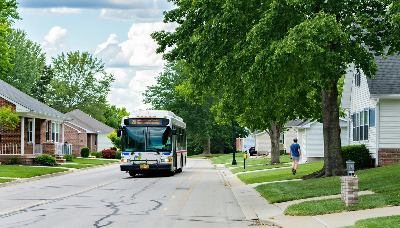
How People Get Around St. Peters
The dominant mobility pattern in St. Peters is car-first, with selective pockets where walking and cycling supplement—but rarely replace—driving. The city’s street network supports high pedestrian-to-road ratios in specific neighborhoods, meaning those areas have invested in sidewalks, crosswalks, and pedestrian pathways that make short trips on foot feasible. Similarly, St. Peters shows notable cycling infrastructure, with bike-to-road ratios that exceed typical suburban thresholds. This doesn’t mean St. Peters functions as a bike-centric city, but it does mean residents in well-connected areas can realistically use a bike for errands, exercise, or short commutes.
For most households, however, the car remains the primary tool for accessing work, groceries, healthcare, and social activities. The city’s layout spreads residential areas across a relatively wide geography, and while some commercial corridors cluster food and grocery options at moderate density, these clusters are not evenly distributed. Residents living outside the walkable pockets or away from the commercial corridors face longer distances between home and daily destinations, making driving the only practical option.
This structure creates a lived experience where transportation convenience depends heavily on neighborhood selection. A household in a pedestrian-friendly pocket near a commercial corridor can walk to a coffee shop, bike to a park, and drive only for larger trips. A household a mile away, in a residential area with minimal sidewalk coverage, will drive for nearly everything. Both live in St. Peters, but their daily mobility—and the time and cost exposure that comes with it—differs significantly.
Public Transit Availability in St. Peters
Public transit plays a limited role in St. Peters. The city does not generate the density or centralized employment hubs that typically support frequent, high-coverage transit service. While regional bus routes may serve portions of St. Peters, connecting residents to broader St. Louis metro destinations, these services are not designed for comprehensive local circulation. Transit works best for residents who live near a stop and commute to a fixed destination along an established route—typically downtown St. Louis or another regional employment center.
For daily errands within St. Peters, transit is rarely a practical option. Grocery stores, medical clinics, schools, and other routine destinations are distributed across corridors and residential zones that transit routes do not densely serve. Even residents with access to a bus stop often find that the time required to wait, transfer, and walk the last leg makes transit impractical compared to a five-minute drive.
Transit dependence in St. Peters is functionally difficult. Households without a car face significant barriers to employment, healthcare access, and daily errands. The city’s infrastructure assumes car ownership, and the absence of a vehicle creates friction that affects nearly every aspect of daily life. For households evaluating St. Peters, transit should be understood as a supplemental option for specific commutes, not a replacement for car ownership.
Driving & Car Dependence Reality
Driving is the default mode of transportation in St. Peters, and the city’s infrastructure reflects that priority. Roads are well-maintained, parking is abundant, and the spacing between residential and commercial areas assumes vehicle access. For most households, this translates to predictable, flexible mobility: you leave when you want, take the route you prefer, and handle multiple stops in a single trip without coordination or waiting.
Car dependence does, however, carry exposure. Households must budget for vehicle purchase or lease, insurance, maintenance, fuel, and occasional repairs. Gas prices in St. Peters currently sit at $2.64 per gallon, which is moderate but still represents a recurring cost that scales with commute distance and errand frequency. Families with multiple drivers or long commutes face higher transportation exposure than those living closer to work or managing with a single vehicle.
Parking in St. Peters is generally not a constraint. Residential areas offer driveways and garages, and commercial areas provide surface lots. Unlike denser urban environments where parking adds cost or limits access, St. Peters removes parking as a friction point. This makes driving more convenient but also reinforces car dependence—there’s little structural incentive to walk, bike, or use transit when driving is faster and easier for nearly every trip.
The tradeoff is time and flexibility versus cost exposure. Driving offers control and convenience, but it locks households into ongoing transportation expenses that don’t fluctuate with usage in the same way transit fares might. A household that drives 20 miles a day and a household that drives 5 miles a day both pay for insurance, registration, and depreciation. Fuel costs vary, but the fixed costs of car ownership remain constant regardless of how much you drive.
Commuting Patterns & Daily Mobility
Commuting in St. Peters typically involves personal vehicles, and the structure of those commutes varies by employment location. Residents working within St. Peters or nearby suburbs often face shorter, more predictable drives, while those commuting to downtown St. Louis, Clayton, or other regional employment centers absorb longer travel times and greater exposure to traffic variability.
The city’s position within the St. Louis metro area makes it a commuter-oriented suburb for many households. Residents choose St. Peters for housing affordability, school access, or neighborhood character, then commute outward for work. This pattern works well for households with flexible schedules or remote work options, but it creates daily time costs for those commuting to fixed-location jobs.
Multi-stop commutes—dropping kids at school, stopping for groceries, picking up dry cleaning—are common in St. Peters, and the city’s layout accommodates this pattern. Commercial corridors cluster along major roads, allowing residents to chain errands efficiently. However, this convenience depends on car access. Households without a vehicle or with limited vehicle availability face significant logistical challenges in managing multi-stop trips.
Proximity matters more in St. Peters than in cities with robust transit. A household living near their workplace, their children’s school, and a grocery corridor experiences far less daily friction than a household facing a 30-minute commute and scattered errand locations. The city’s structure rewards proximity, but it doesn’t penalize distance as severely as denser, more congested metros. Traffic exists but rarely reaches the intensity of major urban centers.
Who Transit Works For — and Who It Doesn’t
Transit in St. Peters works for a narrow slice of residents: those who live near a regional bus stop and commute to a destination served by that route. This typically means commuters heading to downtown St. Louis or other established transit hubs. For these households, transit offers a lower-cost alternative to driving and parking downtown, though it requires schedule coordination and longer travel times.
Transit does not work well for residents whose daily needs are local. Grocery shopping, medical appointments, school pickups, and social activities in St. Peters are not easily accessible via transit. The city’s commercial corridors are designed for car access, and the spacing between stops and destinations makes transit impractical for routine errands.
Renters in walkable pockets near commercial corridors have the most flexibility. They can walk or bike for some errands, drive for others, and potentially use transit for specific commutes. Homeowners in peripheral residential areas, by contrast, face near-total car dependence. The infrastructure simply doesn’t support other modes for most trips.
Households evaluating St. Peters without a car should proceed cautiously. The city’s layout, employment access, and daily errands infrastructure all assume vehicle ownership. While some residents manage with one car instead of two, going car-free in St. Peters creates significant daily friction that affects employment options, healthcare access, and quality of life.
Transportation Tradeoffs in St. Peters
The primary transportation tradeoff in St. Peters is predictability versus cost exposure. Driving offers control, flexibility, and convenience, but it requires ongoing investment in vehicle ownership, fuel, and maintenance. Transit offers lower direct costs but limited coverage, longer travel times, and reduced flexibility. For most households, driving wins on convenience, and the city’s infrastructure reinforces that choice.
Walkable pockets and cycling infrastructure introduce a secondary tradeoff: proximity versus space. Neighborhoods with higher pedestrian density and commercial corridor access tend to offer smaller lots, higher density, and less separation between homes. Residents in these areas gain mobility options but sacrifice some of the spaciousness and quiet that characterize St. Peters’ more car-dependent residential zones.
Time is another dimension. Driving saves time on individual trips but introduces variability based on traffic, weather, and commute distance. Transit eliminates some variability (you know the schedule) but adds wait time, transfer time, and walking time. For households with tight schedules or multiple daily commitments, driving’s time efficiency often outweighs its cost exposure.
The tradeoff isn’t binary. Many households in St. Peters use a mix: driving for most trips, walking or biking for nearby errands, and occasionally using transit for specific commutes. The city’s infrastructure supports this flexibility in some neighborhoods, but it requires intentional location choice. Households prioritizing transportation flexibility should focus on walkable pockets near commercial corridors, while those prioritizing space and quiet may accept greater car dependence in exchange for larger lots and residential separation.
FAQs About Transportation in St. Peters (2026)
Is public transit usable for daily commuting in St. Peters?
Public transit in St. Peters is usable for specific commutes—primarily those heading to downtown St. Louis or other regional transit hubs—but it is not practical for daily errands within the city. Coverage is limited, and the time required for most local trips via transit makes driving far more efficient. Households relying on transit should plan around fixed routes and accept longer travel times.
Do most people in St. Peters rely on a car?
Yes. The vast majority of St. Peters residents rely on personal vehicles for daily mobility. The city’s layout, employment access, and commercial distribution assume car ownership. While some neighborhoods support walking and cycling for short trips, driving remains essential for most households.
Which areas of St. Peters are easiest to live in without a car?
Neighborhoods with higher pedestrian infrastructure density and proximity to commercial corridors offer the most flexibility for reducing car dependence. These walkable pockets allow residents to handle some errands on foot or by bike, though driving is still necessary for many trips. Areas farther from commercial corridors or with minimal sidewalk coverage require near-total car reliance.
How does commuting in St. Peters compare to nearby cities?
Commuting in St. Peters is typical for a St. Louis metro suburb: car-oriented, with moderate traffic and predictable drive times for most routes. Compared to denser urban areas closer to downtown, St. Peters offers easier parking and less congestion but longer distances to regional employment centers. Compared to more rural areas, St. Peters provides better road infrastructure and shorter drives to commercial amenities.
Does St. Peters have good cycling infrastructure?
St. Peters has notable cycling infrastructure relative to typical suburban environments, with bike-to-road ratios that support recreational and some utilitarian cycling. However, cycling as a primary transportation mode is practical only for residents living near destinations and comfortable navigating mixed-traffic conditions. The infrastructure exists but does not create a bike-centric mobility environment.
How Transportation Fits Into the Cost of Living in St. Peters
Transportation in St. Peters functions as a structural cost driver, not just a budget line. The city’s car-dependent layout means most households must own at least one vehicle, and many need two. This introduces fixed costs—insurance, registration, depreciation—that persist regardless of how much you drive. Fuel costs, currently $2.64 per gallon, add variable exposure based on commute distance and errand frequency, but the baseline cost of car ownership is unavoidable for most residents.
Housing location decisions directly affect transportation exposure. A household choosing a home near their workplace or within a walkable pocket reduces daily driving, which lowers fuel costs and vehicle wear. A household prioritizing a larger lot or specific school district may accept a longer commute and higher transportation costs in exchange. These tradeoffs are not always explicit, but they shape long-term cost exposure in ways that compound over years.
For a fuller picture of how transportation costs interact with housing, utilities, and other expenses, see Your Monthly Budget in St. Peters: Where It Breaks. That article provides numeric context for how transportation fits into overall household spending and where different choices create leverage or lock in fixed costs.
St. Peters rewards intentional location choice. Households that prioritize proximity, walkable access, and cycling infrastructure can reduce transportation exposure without sacrificing suburban character. Those who prioritize space, quiet, or specific residential features will likely accept greater car dependence and the costs that come with it. Neither choice is wrong, but both carry long-term implications for time, flexibility, and financial exposure. Understanding how transportation works in St. Peters—and where your household fits within that structure—turns mobility from a background assumption into a decision point you control.
How this article was built: In addition to public economic data, this article incorporates location-based experiential signals derived from anonymized geographic patterns—such as access density, walkability, and land-use mix—to reflect how day-to-day living actually feels in St. Peters, MO.