Can you get by without a car in Land O Lakes? For most residents, the answer is no—but understanding why requires looking at how the city is built, not just what transit exists. Land O Lakes sits in a low-rise, suburban layout where daily errands, work commutes, and household logistics typically require personal transportation. While bus service is present and some neighborhoods support moderate walkability, the overall structure of the area favors driving. That doesn’t mean transit plays no role, but it does mean that most households treat a car as essential infrastructure rather than optional convenience.
This article explains how people actually move through Land O Lakes: what public transit covers, where driving becomes necessary, and which household types can realistically build routines around transit versus those who absorb commute friction behind the wheel. If you’re deciding whether to bring a car, evaluating a neighborhood’s accessibility, or trying to understand how mobility shapes daily costs and time, this guide walks through the transportation reality on the ground.
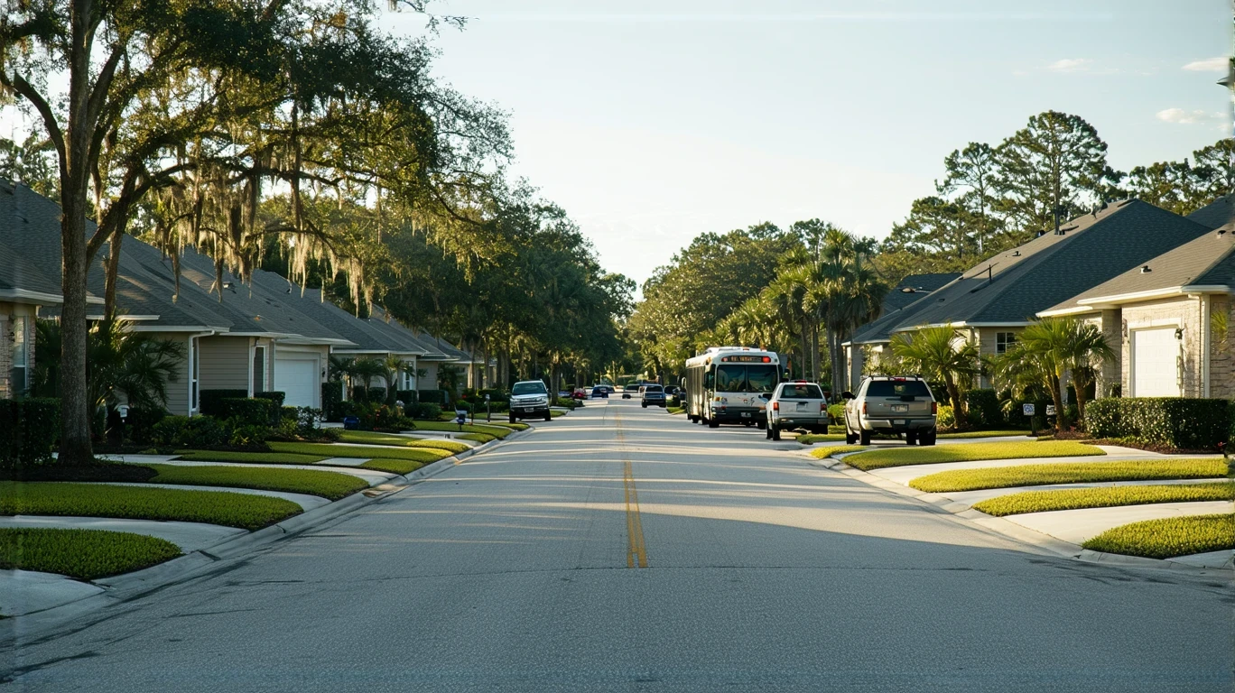
How People Get Around Land O Lakes
Land O Lakes operates primarily as a car-first community. The area’s development pattern—low-rise residential neighborhoods interspersed with commercial corridors—creates distances that make walking or biking practical only within limited pockets. Most residents drive for work, groceries, appointments, and errands. The pedestrian-to-road ratio sits in a moderate band, meaning sidewalks and pathways exist in parts of the city, but they don’t form a continuous network that supports car-free living across most of the area.
Bus service is available and provides a baseline transit option, but coverage and frequency are shaped by suburban geography. Routes tend to serve major corridors and key destinations rather than offering dense, neighborhood-level access. For someone living near a bus line and working along a served route, transit can function as a secondary option or backup. For most others, it remains a supplement rather than a primary mode.
Cycling infrastructure exists in some pockets, with bike-to-road ratios in the medium band. This means dedicated lanes or paths appear in certain areas, but the network isn’t comprehensive. Biking works well for recreation or short, planned trips within familiar zones, but it doesn’t replace a car for most daily logistics.
What newcomers often misunderstand is that Land O Lakes isn’t designed around transit hubs or walkable downtowns. It’s a suburban environment where residential and commercial land uses are present but separated by distances that favor driving. That structure doesn’t make the city unwalkable—it means walkability is localized rather than citywide, and most households plan their routines around vehicle access.
Public Transit Availability in Land O Lakes
Public transit in Land O Lakes centers around bus service. The system provides connections along key corridors and links residential areas to commercial zones, employment centers, and regional destinations. For residents who live near a stop and whose destinations align with existing routes, transit offers a viable option for specific trips—commuting to a fixed workplace, reaching a shopping district, or accessing services along a main road.
Where transit works best is along established corridors where stops are spaced to serve higher-density commercial areas or transfer points. Riders who can structure their schedules around available service and who don’t need to make multi-stop trips across dispersed locations find transit more practical. Students, service workers with fixed shifts, and households managing single-destination commutes are more likely to integrate bus service into their routines.
Where transit falls short is in coverage of lower-density residential neighborhoods, late-evening or weekend service, and multi-leg trips that require transfers or detours. The suburban layout means many homes sit outside easy walking distance of a stop, and reaching a bus line may itself require a car or a long walk. For households juggling daycare pickups, grocery runs, and variable work hours, transit’s limited flexibility becomes a constraint rather than a solution.
Transit in Land O Lakes plays a supporting role rather than a primary one. It’s present, functional for certain use cases, and expands mobility options for residents who can align their needs with its structure—but it doesn’t eliminate car dependence for most households.
Driving & Car Dependence Reality
Driving is the default mode of transportation in Land O Lakes, not because residents prefer it universally, but because the city’s geography and infrastructure make it the most practical choice for daily life. Errands are dispersed, employment centers are spread across the region, and the distances between home, work, and services are structured around vehicle access. Parking is generally available and straightforward, which reduces one of the friction points that makes driving costly or stressful in denser urban areas.
Car dependence here is tied to suburban form. Residential neighborhoods are separated from commercial zones by distances that take minutes by car but would require significant time on foot or by bike. Grocery stores, medical offices, schools, and workplaces are accessible, but they’re rarely clustered within a single walkable radius. For families managing multiple stops—dropping kids at school, commuting to work, picking up groceries, attending appointments—driving offers the flexibility and speed that transit and walking can’t match.
The tradeoff is exposure to vehicle costs: fuel, insurance, maintenance, and depreciation. Gas prices in the area currently sit at $2.84 per gallon, which factors into the ongoing cost of car ownership. But for most households, those costs are weighed against the time savings, convenience, and access that driving provides. In a layout where transit coverage is limited and errands are spread out, the car becomes essential infrastructure rather than optional mobility.
For newcomers evaluating whether they can live without a car, the question isn’t whether it’s technically possible—it’s whether the tradeoffs in time, flexibility, and daily logistics are sustainable. In Land O Lakes, most households conclude they’re not.
Commuting Patterns & Daily Mobility
Commuting in Land O Lakes typically involves driving to employment centers within the broader Tampa metro area or to nearby commercial and industrial zones. The area functions as part of a regional commuter network, where residents may work locally or travel to neighboring cities depending on their industry and employer. Commutes are structured around highways and major roads, and most workers drive alone rather than carpooling or using transit.
Daily mobility extends beyond the work commute. Households manage school runs, grocery trips, medical appointments, and errands that require multiple stops across different parts of the city or region. The suburban layout means these trips are rarely consolidated into a single walkable district. Instead, they’re distributed across corridors and zones, each requiring a separate drive. For families with children, this pattern intensifies: school drop-offs, after-school activities, and weekend logistics all depend on vehicle access.
Who benefits from proximity? Residents who live near their workplace or whose jobs are located along well-served corridors can reduce commute time and fuel costs. Remote workers and flexible-schedule employees gain the most control, as they can avoid peak traffic and reduce the frequency of trips. But for households with fixed schedules, multiple jobs, or caregiving responsibilities, commute friction is absorbed as part of the baseline cost of living in a car-dependent area.
The unemployment rate in the area is currently 3.7%, reflecting a relatively stable labor market. For workers entering or re-entering the job market, understanding how commuting shapes daily routines and expenses is part of evaluating whether a job offer or housing location makes practical sense.
Who Transit Works For — and Who It Doesn’t
Public transit in Land O Lakes works best for households whose routines align with existing bus routes and who can tolerate the time and flexibility tradeoffs that come with limited service. Single adults commuting to a fixed workplace along a served corridor, students traveling to campus or school, and service workers with predictable shifts are more likely to integrate transit into their daily lives. For these groups, bus service reduces vehicle costs and provides a functional alternative for specific, recurring trips.
Transit works less well for families managing complex logistics. Parents coordinating school pickups, daycare schedules, and grocery runs face challenges when transit requires transfers, long waits, or routes that don’t align with their destinations. Households with multiple wage earners working in different locations, or those whose jobs require evening or weekend hours, find that bus service doesn’t cover their needs consistently enough to replace a car.
Renters living near bus stops in more central or corridor-adjacent neighborhoods have better access to transit than those in peripheral subdivisions. But even proximity to a stop doesn’t guarantee that transit will serve all destinations efficiently. Homeowners in lower-density residential areas—where much of Land O Lakes’ housing stock is concentrated—are almost universally car-dependent, as transit coverage thins out in these zones.
The fit comes down to whether your daily routine can be structured around transit’s limitations. If your life requires flexibility, speed, or access to dispersed locations, transit becomes a backup rather than a primary mode. If your routine is predictable, your destinations are served, and you’re willing to trade time for lower vehicle costs, transit can play a meaningful role.
Transportation Tradeoffs in Land O Lakes
Choosing between transit and driving in Land O Lakes isn’t about which mode is objectively better—it’s about which tradeoffs fit your household’s priorities and constraints. Driving offers control, flexibility, and speed. You leave when you’re ready, take the most direct route, and handle multi-stop trips without transfers or waiting. The cost is ongoing vehicle expenses: fuel, insurance, maintenance, and the financial exposure that comes with car ownership.
Transit offers predictability in operating costs and eliminates the need to manage a vehicle, but it trades away flexibility and time. Routes are fixed, schedules are limited, and trips that take minutes by car can stretch into longer journeys when walking to stops, waiting, and transferring are factored in. For households that can absorb those time costs and whose routines align with available service, transit reduces financial exposure. For those who can’t, the time cost becomes unsustainable.
Biking works well for short, planned trips within neighborhoods that have dedicated infrastructure, but it doesn’t replace a car for most daily logistics. The bike-to-road ratio in Land O Lakes sits in a moderate band, meaning infrastructure exists but isn’t comprehensive. Cycling is practical for recreation, fitness, or specific errands within familiar zones, but it’s not a primary commuting mode for most residents.
The broader tradeoff is between suburban layout and mobility options. Land O Lakes’ low-rise, dispersed development pattern creates space, affordability in housing, and a quieter residential environment—but it also locks in car dependence for most households. That dependence isn’t a failure of planning; it’s a structural feature of suburban form. Understanding that structure helps you evaluate whether the transportation costs and time commitments fit your household’s budget and lifestyle.
FAQs About Transportation in Land O Lakes (2026)
Is public transit usable for daily commuting in Land O Lakes?
Public transit is usable for specific commutes, particularly those that follow major corridors and align with existing bus routes. If your workplace is located along a served route and your schedule fits available service times, transit can function as a reliable option. For commutes that require transfers, serve dispersed destinations, or depend on evening or weekend service, transit becomes less practical, and most residents rely on driving instead.
Do most people in Land O Lakes rely on a car?
Yes. The majority of residents in Land O Lakes depend on a car for daily transportation. The area’s suburban layout, dispersed errands, and limited transit coverage make driving the most practical mode for work commutes, grocery runs, school logistics, and household errands. While bus service exists and some neighborhoods support moderate walkability, the overall structure of the city favors vehicle access.
Which areas of Land O Lakes are easiest to live in without a car?
Neighborhoods located near bus stops along major corridors and within walking distance of grocery stores, pharmacies, or other daily services offer the best chance of reducing car dependence. Even in these areas, however, most residents find that a car remains necessary for trips that fall outside transit coverage or require flexibility. Living without a car in Land O Lakes is possible for households with predictable routines and limited mobility needs, but it’s not the norm.
How does commuting in Land O Lakes compare to nearby cities?
Commuting in Land O Lakes reflects the broader Tampa metro area’s car-dependent structure. Compared to denser urban centers with more extensive transit networks, Land O Lakes offers less frequent service and fewer route options. Compared to other suburban communities in the region, it’s similar: driving dominates, transit serves as a supplement, and commute patterns are shaped by regional employment centers and highway access.
Can you bike to work in Land O Lakes?
Biking to work is feasible for residents whose workplaces are located within a few miles of home and along routes with dedicated cycling infrastructure. The bike-to-road ratio in Land O Lakes sits in a moderate band, meaning some infrastructure exists but isn’t comprehensive. For most commuters, biking is limited by distance, traffic conditions, and Florida’s heat and humidity, making it more practical for recreation or short trips than for daily work commutes.
How Transportation Fits Into the Cost of Living in Land O Lakes
Transportation in Land O Lakes isn’t just a line item in your monthly budget—it’s a structural factor that shapes where you can live, how you spend your time, and what flexibility you have in daily life. Car dependence creates ongoing financial exposure through fuel, insurance, maintenance, and depreciation, but it also provides the speed and flexibility that suburban geography demands. For most households, those costs are non-negotiable because the alternative—relying solely on transit or biking—doesn’t align with the city’s layout or the logistics of work, school, and errands.
Understanding how transportation works in Land O Lakes helps you evaluate housing choices more clearly. Living closer to work, near a bus line, or within walking distance of key services can reduce commute time and fuel costs, but those locations may come with higher rent or home prices. Living farther out may lower housing costs but increase transportation expenses and time spent commuting. The tradeoff isn’t about finding a perfect solution—it’s about identifying which combination of location, cost, and mobility fits your household’s priorities.
If you’re planning a move to Land O Lakes or trying to understand how mobility shapes daily expenses, start by mapping your routine: where you’ll work, where your kids will go to school, where you’ll shop, and how often you’ll need to make trips outside your immediate neighborhood. That map will show you whether transit can realistically serve your needs or whether a car is essential. For most households, the answer is clear before they arrive—but understanding why makes the decision easier to navigate.
How this article was built: In addition to public economic data, this article incorporates location-based experiential signals derived from anonymized geographic patterns—such as access density, walkability, and land-use mix—to reflect how day-to-day living actually feels in Land O Lakes, FL.