Can you live in Encinitas without a car? The answer depends less on whether transit exists and more on where you live within the city and how your daily life is structured. Encinitas sits along the San Diego County coast with a layout that creates pockets of walkability alongside stretches where driving remains the default. Rail service runs through the city, bike infrastructure is notably present, and certain corridors offer genuine pedestrian access—but the experience of getting around varies sharply depending on your neighborhood and routine.
This article explains how people actually move through Encinitas: what transit options exist, where car dependence kicks in, and which household types benefit from proximity versus those who absorb commute friction as part of the tradeoff for living here.
How People Get Around Encinitas
Encinitas operates as a mixed-mobility city with distinct zones. In walkable pockets—typically near downtown cores and along certain commercial corridors—pedestrian infrastructure is substantial relative to the road network, and daily errands are broadly accessible on foot. Bike infrastructure is present throughout parts of the city, with bike-to-road ratios that exceed typical suburban thresholds. These areas support a lifestyle where short trips, errands, and recreational movement don’t require a car.
Outside these pockets, the city’s layout shifts. Residential neighborhoods spread across hillsides and inland zones where sidewalks thin out, distances lengthen, and the car becomes the practical default. Even residents who live in walkable areas often keep a vehicle for trips beyond their immediate zone—whether commuting to jobs in the broader San Diego metro, running multi-stop errands, or accessing services that aren’t clustered near home.
What newcomers often misunderstand is that Encinitas isn’t uniformly car-dependent or uniformly walkable. It’s segmented. Your mobility experience is determined by your specific address, your daily destinations, and whether your routine aligns with the infrastructure that exists in your part of the city.
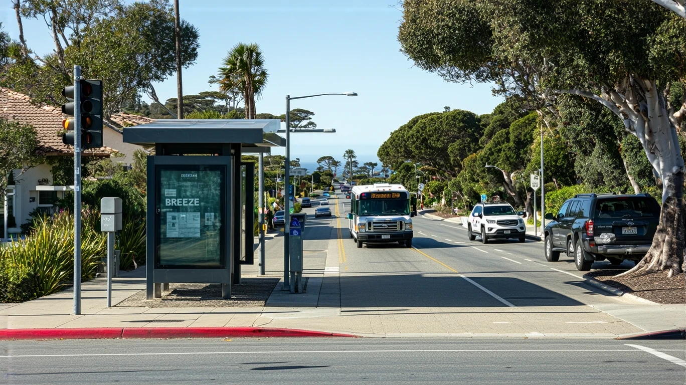
Public Transit Availability in Encinitas
Public transit in Encinitas often centers around rail service, which provides a north-south connection along the coast and links residents to employment centers, universities, and regional destinations within San Diego County. Rail access is a meaningful differentiator for households whose work or lifestyle aligns with the corridor it serves. For commuters heading into downtown San Diego or other rail-accessible zones, the presence of this service reduces car dependence and offers predictability that driving along congested coastal routes does not.
Bus service is also present, though coverage and frequency vary by area. Transit tends to work best along main corridors and near commercial nodes where density and foot traffic support more frequent service. In lower-density residential areas—particularly those set back from the coast or spread across hillier terrain—transit becomes less practical for daily use. Late-night service, weekend frequency, and coverage to peripheral neighborhoods are typically limited, which means households relying on transit need to structure their routines around the available schedule rather than the other way around.
Transit in Encinitas plays a supplemental role for most residents. It works well for specific trips—commuting along the rail line, accessing regional destinations, or avoiding parking friction in denser areas—but it doesn’t replace the car for most households. The system supports certain lifestyles and commutes; it doesn’t blanket the city with universal access.
Driving & Car Dependence Reality
For the majority of Encinitas residents, driving remains necessary for daily life. Grocery runs, medical appointments, school drop-offs, and errands that require multiple stops are difficult to manage without a vehicle, even in walkable pockets. Parking is generally available and less constrained than in denser urban cores, which reduces one friction point associated with car ownership. The tradeoff is that distance and sprawl create time costs: trips that look short on a map can take longer than expected due to terrain, traffic patterns, and the indirect routes required to navigate the city’s layout.
Car dependence in Encinitas is tied to geography and infrastructure, not preference. Households living in peripheral or hillside neighborhoods have few alternatives. Even those near transit corridors often find that the car offers flexibility that transit schedules can’t match—particularly for trips that don’t align with rail or bus routes, or for households managing complex logistics like childcare, aging parents, or irregular work hours.
Owning a car here isn’t just about commuting. It’s about maintaining access to the full range of services, employment, and social infrastructure spread across a region where density is uneven and destinations are dispersed. The city’s layout rewards car ownership with convenience and control, even as it imposes the costs and responsibilities that come with it.
Commuting Patterns & Daily Mobility
Commuting in Encinitas reflects the city’s role as both a residential community and a coastal destination within the larger San Diego metro. Many residents commute out of the city for work, often heading south toward downtown San Diego, east toward inland employment centers, or north along the coast. Rail service supports some of these commutes, particularly for those working in areas accessible by the regional network. For others, driving remains the only practical option, especially for jobs in suburban office parks, industrial zones, or locations without transit connections.
Daily mobility isn’t just about the work commute. Households here often structure their days around multi-stop trips: dropping kids at school, running errands, picking up groceries, and managing appointments. This kind of routine is difficult to accomplish on transit, even in areas with decent coverage. The car becomes the tool that makes these complex logistics manageable, particularly for families, retirees managing medical appointments, or anyone balancing multiple responsibilities across dispersed locations.
Proximity matters. Residents who live near their workplace, near schools, or within walking distance of daily services experience Encinitas differently than those who commute long distances or live in areas where every trip requires a car. The city rewards those whose routines align with its infrastructure and penalizes those whose don’t—not through policy, but through time, friction, and the累 cumulative cost of distance.
Who Transit Works For — and Who It Doesn’t
Transit in Encinitas works best for a specific subset of households: those living near rail stations or major bus corridors, whose work or daily destinations align with the routes served, and who have schedules flexible enough to accommodate transit timing. Retirees with flexible schedules, remote workers making occasional trips into the city, and commuters heading to rail-accessible employment centers are the most likely to benefit. For these groups, transit reduces car dependence without requiring a complete lifestyle restructure.
Transit works less well for families managing school schedules, households with multiple wage earners commuting in different directions, and residents living in peripheral neighborhoods where coverage is sparse. It also struggles to serve shift workers, late-night commuters, and anyone whose routine requires multi-stop trips or access to destinations not served by existing routes. These households face a choice: accept the constraints of transit and adjust their lives accordingly, or rely on a car and absorb the associated costs.
Renters in core areas near transit have more flexibility to test whether a car-light or car-free lifestyle works for them. Owners in peripheral neighborhoods, particularly those in hillside or inland zones, are functionally locked into car dependence. The infrastructure doesn’t support alternatives, and the distances involved make walking or biking impractical for most daily needs.
Transportation Tradeoffs in Encinitas
Choosing between transit and driving in Encinitas isn’t about cost alone—it’s about control, predictability, and how much friction you’re willing to accept in exchange for flexibility. Transit offers lower direct costs and eliminates parking hassles, but it requires you to structure your life around fixed schedules and limited coverage. Driving offers convenience and control, but it comes with fuel exposure, maintenance responsibilities, and the time cost of navigating traffic and distance.
For households whose routines align with transit infrastructure, the tradeoff tilts toward transit. For those managing complex logistics, living outside walkable zones, or commuting to areas without rail access, the tradeoff tilts toward driving. The city doesn’t force one choice or the other, but it does reward certain patterns and penalize others through the friction embedded in its layout.
The real tradeoff isn’t transit versus driving—it’s proximity versus space, convenience versus cost, and predictability versus flexibility. Where you live in Encinitas and how your daily life is structured determines which side of that tradeoff you’re on.
FAQs About Transportation in Encinitas (2026)
Is public transit usable for daily commuting in Encinitas?
Public transit is usable for daily commuting if your work or regular destinations align with the rail line or major bus corridors. Rail service provides reliable access to parts of the San Diego metro, particularly for commuters heading south along the coast. Outside these corridors, transit becomes less practical, and most residents rely on cars for daily commuting.
Do most people in Encinitas rely on a car?
Yes. Most residents rely on a car for daily life, even those living in walkable areas. The city’s layout, the dispersion of services, and the need to manage multi-stop errands make car ownership the practical default for the majority of households. Transit serves specific commutes and trips, but it doesn’t replace the car for most people.
Which areas of Encinitas are easiest to live in without a car?
Areas near rail stations and along commercial corridors with high pedestrian infrastructure and dense errands access are the easiest to navigate without a car. These walkable pockets support daily life on foot or by bike for short trips, though most residents in these areas still keep a vehicle for longer trips or errands outside their immediate zone.
How does commuting in Encinitas compare to nearby cities?
Commuting in Encinitas reflects its position within the San Diego metro: rail access provides a meaningful advantage for certain commutes, but car dependence remains high compared to denser urban cores. Compared to inland suburban cities without rail, Encinitas offers more transit options. Compared to downtown San Diego or other transit-rich areas, it still requires more driving for most households.
Can you bike for transportation in Encinitas?
Yes, biking is viable in parts of Encinitas. Bike infrastructure is notably present, with bike-to-road ratios that exceed typical suburban levels. Biking works well for short trips within walkable pockets and along certain corridors, though terrain, distance, and traffic patterns limit its practicality for longer commutes or trips to peripheral areas.
How Transportation Fits Into the Cost of Living in Encinitas
Transportation in Encinitas isn’t just a line item—it’s a structural factor that shapes where you can live, how much time you spend moving through your day, and how much control you have over your routine. Households near transit corridors gain flexibility and reduce car dependence, which lowers direct transportation exposure. Households in peripheral areas absorb higher transportation costs and time burdens, but often gain more space and lower housing pressure in exchange.
The city’s mixed mobility pattern means that transportation decisions are tied to housing decisions. Choosing proximity to transit or walkable infrastructure often means paying more for housing or accepting smaller living spaces. Choosing peripheral neighborhoods with lower housing costs often means accepting higher transportation costs and car dependence. There’s no universal “best” choice—only tradeoffs that align differently depending on your household structure, work location, and daily routine.
Understanding how you’ll actually move through Encinitas—and what that movement will cost in time, money, and friction—is essential to making a grounded decision about whether this city fits your life. The infrastructure exists to support certain patterns; your job is to figure out whether your pattern is one of them.
How this article was built: In addition to public economic data, this article incorporates location-based experiential signals derived from anonymized geographic patterns—such as access density, walkability, and land-use mix—to reflect how day-to-day living actually feels in Encinitas, CA.