How People Get Around Elgin
Understanding transportation options in Elgin starts with recognizing a fundamental split: the city offers rail access to Chicago’s job centers, but daily life here still revolves around the car. Newcomers often assume proximity to the metro means robust local transit—it doesn’t. What Elgin provides is selective connectivity: strong commuter rail for those living near stations and heading downtown, but limited help for groceries, errands, or cross-town trips.
The layout reinforces this division. Walkable pockets exist around the historic downtown core, where pedestrian infrastructure is denser and mixed-use development creates short errand loops. But step outside those zones, and the street grid quickly shifts to car-first design—wider roads, longer blocks, fewer sidewalks. Rail service doesn’t change that structure; it just gives Chicago commuters an escape hatch from the daily grind of driving into the Loop.
What people misunderstand most is coverage. Transit here isn’t a citywide utility—it’s a commuter lifeline for a specific use case. If your job, routine, and housing align with that corridor, Elgin’s transit works. If not, you’re driving, and the city’s infrastructure assumes you will be.
Public Transit Availability in Elgin
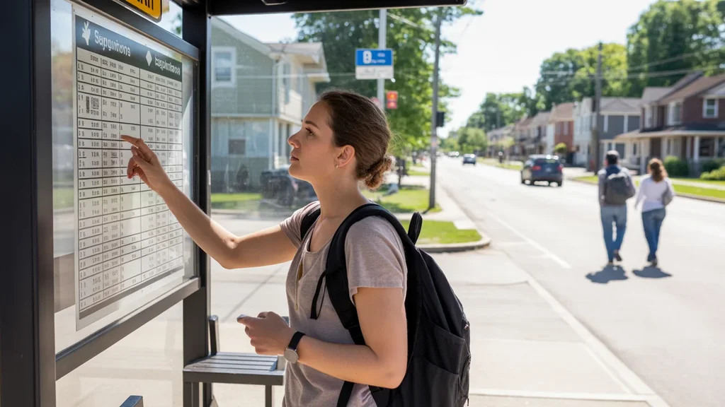
Public transit in Elgin often centers around systems such as Metra, which connects the city to Chicago’s downtown core via commuter rail. This isn’t frequent all-day service—it’s peak-oriented, designed for traditional work schedules. Trains run more often during morning and evening rush hours, then taper off midday and disappear entirely late at night. Weekend service exists but operates on a reduced schedule.
Where transit works best is obvious: near the stations. Live within walking or biking distance of a Metra stop, and you have a real alternative to driving into Chicago. That proximity matters because local bus service, while present, doesn’t offer the same reach or reliability. Routes tend to follow main corridors, leaving gaps in outer neighborhoods and requiring careful planning for anything beyond a straight shot downtown.
Where it falls short is equally clear. If your job isn’t in Chicago’s core, if you work non-traditional hours, or if your errands span multiple parts of Elgin, transit becomes a constraint rather than a tool. The system wasn’t built for intra-city mobility—it was built to move suburban commuters into the Loop and back. That’s a narrow mission, and it shows in the schedule, the coverage map, and the rider experience.
Driving & Car Dependence Reality
For most households in Elgin, driving isn’t optional—it’s structural. The city’s development pattern, like much of suburban Chicagoland, assumes car ownership. Grocery stores, schools, medical offices, and retail clusters sit along arterial roads designed for vehicle access, not foot traffic. Parking is abundant and free in most areas, which removes one of the friction points that makes urban car ownership expensive and annoying.
This setup creates flexibility but also cost structure exposure. Gas prices in the area run $4.23 per gallon, and while that’s not extreme by national standards, it adds up quickly when every errand requires a round trip. Maintenance, insurance, and registration costs layer on top, and unlike transit, there’s no off-peak discount—your car costs the same whether you drive it daily or occasionally.
The tradeoff is control. Driving lets you chain errands, adjust timing on the fly, and reach destinations transit doesn’t serve. For families managing school pickups, weekend activities, and multi-stop shopping runs, that flexibility is non-negotiable. The cost is predictable only in direction—it rises with usage, distance, and vehicle age—but the alternative (being stranded without a car) feels worse to most residents.
Commuting Patterns & Daily Mobility
Commuting in Elgin breaks into two distinct patterns. Chicago-bound commuters with rail access structure their lives around the train schedule—early departures, fixed return times, and housing choices that prioritize station proximity. These households treat the commute as a known constant: predictable in duration, immune to traffic, but rigid in timing.
Everyone else drives. That includes people working in Elgin’s local economy, those commuting to nearby suburbs like Schaumburg or Hoffman Estates, and anyone whose job hours don’t align with peak rail service. These commutes vary widely in distance and time, but they share a common thread: total car dependence. There’s no fallback if the vehicle breaks down, no alternative if gas prices spike, and no way to avoid the cumulative time cost of stop-and-go suburban traffic.
Daily mobility beyond work follows the same logic. Errands, appointments, and social trips default to driving because the city’s layout makes walking or biking impractical for most origin-destination pairs. Even in the walkable downtown pockets, residents often drive to access services outside that zone. The result is a mobility system that works well for one specific use case—Chicago commuting—and leaves everyone else managing their own transportation logistics.
Who Transit Works For — and Who It Doesn’t
Transit in Elgin works for a narrow slice of households: those who live near a Metra station, work traditional hours in downtown Chicago, and can structure their daily errands around car-free or car-light living within walkable pockets. Renters in the historic core, young professionals prioritizing reverse-commute avoidance, and couples willing to trade convenience for lower transportation costs all fit this profile.
It doesn’t work for families managing school runs, extracurriculars, and weekend logistics across multiple parts of the city. It doesn’t work for shift workers, healthcare employees, or anyone whose job sits outside the Chicago Loop. And it doesn’t work for households in Elgin’s outer neighborhoods, where station access requires a car anyway—eliminating the cost advantage of going car-free.
The gap isn’t about effort or preference; it’s about infrastructure. Elgin’s street network, land-use pattern, and service density were built assuming car ownership. Transit was layered on top as a commuter amenity, not a replacement for driving. That’s not a criticism—it’s a description of how the system actually functions and who it realistically serves.
Transportation Tradeoffs in Elgin
Choosing between transit and driving in Elgin isn’t about comparing monthly costs—it’s about comparing systems. Transit offers predictability: fixed schedules, no parking hassles, immunity to traffic. But it demands proximity, schedule alignment, and acceptance of limited coverage. Driving offers flexibility: any destination, any time, any cargo. But it demands upfront vehicle costs, ongoing maintenance, and exposure to fuel price swings.
For Chicago commuters, the tradeoff tilts toward transit if housing near a station is affordable and daily errands can be managed without a car. That’s a big if. Many households end up hybrid: one car for errands and non-commute trips, rail for the daily Loop run. That setup reduces driving costs but doesn’t eliminate them, and it requires living in the narrow geographic band where both modes are viable.
For everyone else, the tradeoff collapses into a single option: driving. There’s no realistic alternative for cross-town trips, late-night shifts, or multi-stop logistics. The question then becomes not whether to own a car, but how much driving the household can absorb before time and cost pressure outweigh the benefits of Elgin’s relatively affordable housing and solid family infrastructure.
FAQs About Transportation in Elgin (2026)
Is public transit usable for daily commuting in Elgin?
Yes, but only for a specific commute profile: traditional work hours in downtown Chicago, with housing near a Metra station. The rail service is peak-oriented and designed for Loop commuters, not for local trips within Elgin or to suburban job centers. If your job fits that pattern, transit works well. If not, you’ll be driving.
Do most people in Elgin rely on a car?
Yes. The city’s layout, errand density, and service gaps make car ownership the default for most households. Even residents who use Metra for commuting typically own a car for groceries, appointments, and weekend trips. Going fully car-free is possible only in limited walkable pockets near downtown, and even then it requires careful planning.
Which areas of Elgin are easiest to live in without a car?
The historic downtown core and neighborhoods within walking distance of Metra stations offer the best shot at car-free or car-light living. These areas have denser pedestrian infrastructure, mixed-use development, and proximity to both rail service and local errands. Outside those zones, car dependence rises sharply.
How does commuting in Elgin compare to nearby cities?
Elgin offers stronger rail access to Chicago than many outer suburbs, but weaker local transit than inner-ring communities. Compared to places like Naperville or Aurora, Elgin’s commuter rail service is competitive, but its intra-city mobility options are similarly car-dependent. The advantage here is Chicago access, not local connectivity.
Can you bike for transportation in Elgin?
Biking infrastructure exists in pockets, particularly around downtown and near parks, but it’s not a citywide network. Cycling works for short recreational trips or targeted errands within the core, but the street layout and traffic patterns make it impractical for most commuting or cross-town travel. Biking here is supplemental, not primary.
How Transportation Fits Into the Cost of Living in Elgin
Transportation in Elgin isn’t just a line item—it’s a structural factor that shapes housing choice, time allocation, and household flexibility. Proximity to a Metra station can reduce driving costs but often commands higher rent or home prices. Living farther out lowers housing expenses but increases car dependence, fuel consumption, and commute friction. There’s no free optimization; every choice trades one form of cost or constraint for another.
What makes Elgin distinct is the selectivity of its transit advantage. If your life aligns with the rail corridor—Chicago job, walkable errands, predictable schedule—you gain real leverage over transportation costs and time. If not, you’re managing the same car-dependent logistics as any other suburban household, with the same exposure to fuel prices, maintenance cycles, and vehicle depreciation.
For a fuller picture of how transportation costs interact with housing, utilities, and household budgets, see Your Monthly Budget in Elgin: Where It Breaks. The key insight is this: transportation here isn’t a problem to solve—it’s a system to understand, and your fit with that system determines whether Elgin’s overall cost structure works in your favor or against it.
How this article was built: In addition to public economic data, this article incorporates location-based experiential signals derived from anonymized geographic patterns—such as access density, walkability, and land-use mix—to reflect how day-to-day living actually feels in Elgin, IL.