Can you live in Draper without a car? It’s one of the first questions people ask when considering a move here, and the answer depends heavily on where you land and what your daily routine looks like. Draper sits in Utah’s Salt Lake Valley, a region where car ownership has long been the default but where transit infrastructure has quietly expanded in recent years. The city’s layout—a mix of established neighborhoods, newer subdivisions, and commercial corridors—creates a transportation reality that’s neither fully car-dependent nor genuinely transit-rich. Some residents rely on rail and bus service for daily commutes, while others find that getting around without a vehicle means constant logistical friction.
Understanding transportation options in Draper means recognizing that mobility here is shaped by infrastructure that serves some areas well and leaves others isolated. Rail transit runs through parts of the city, pedestrian infrastructure is concentrated in pockets, and errands tend to cluster along specific corridors rather than spreading evenly across neighborhoods. For newcomers, the surprise often isn’t whether transit exists—it does—but whether it connects to the places they actually need to go.
How People Get Around Draper
Most people in Draper drive. That’s the baseline reality, rooted in the city’s suburban form and the way residential areas spread across terrain that doesn’t always lend itself to dense, walkable grids. But “most” doesn’t mean “all,” and the distinction matters. Draper has rail service that connects residents to broader regional employment and activity centers, and in neighborhoods near transit stations, some households structure their lives around that access. Pedestrian infrastructure is notably strong in certain areas—where sidewalks, crossings, and pathways create genuine walkability—but those pockets don’t extend uniformly across the city.
The dominant pattern is car-first with selective transit use. People drive to work, drive to groceries, drive to errands. But a subset of residents—often those living near rail corridors or within Draper’s more pedestrian-friendly zones—use transit for commuting and save driving for tasks that require it. The average commute in Draper is around 23 minutes, and about 31.6% of workers face longer commutes, suggesting that many residents work outside the immediate area and rely on highway access or transit lines to reach employment hubs.
What newcomers often misunderstand is that Draper’s transit presence doesn’t eliminate the need for a car—it supplements it. Even households that use rail regularly tend to own vehicles for flexibility, weekend trips, and errands that fall outside transit coverage. The city’s layout rewards those who can drive, but it doesn’t completely strand those who can’t.
Public Transit Availability in Draper
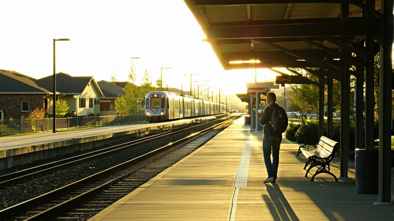
Public transit in Draper often centers around systems such as UTA (Utah Transit Authority), which operates rail and bus service throughout the Salt Lake Valley. Rail transit is present in Draper, providing a direct connection to Salt Lake City and other regional destinations. This is a meaningful asset, particularly for commuters who work in downtown Salt Lake or along the rail corridor. The presence of rail service distinguishes Draper from purely car-dependent suburbs and creates genuine transit viability for households positioned near stations.
But transit coverage is uneven. Rail serves specific corridors, and bus routes extend that reach somewhat, but large portions of Draper—especially newer subdivisions on the city’s edges—remain outside practical walking distance to transit stops. For residents in those areas, using public transit means driving to a park-and-ride or arranging a ride to a station, which undermines much of the convenience transit is supposed to provide. Late-evening and weekend service tends to be less frequent, and routes are designed primarily around commuter patterns rather than all-day, all-purpose mobility.
Transit works best in Draper for people who live near rail stations and work along the same corridor. It works less well for those whose jobs, errands, or daily routines require cross-town travel or access to areas not served by fixed routes. The system exists, and it’s real, but it’s not comprehensive.
Driving & Car Dependence Reality
Driving in Draper is straightforward. Roads are generally well-maintained, parking is abundant, and traffic congestion—while present during peak hours—rarely approaches the gridlock seen in denser metro areas. For most residents, a car provides the flexibility to manage work, errands, and household logistics without the constraints of transit schedules or coverage gaps. The city’s geography, with residential neighborhoods spreading across hillsides and valleys, makes driving the most practical option for reaching grocery stores, schools, medical appointments, and recreational destinations.
Car dependence here isn’t just about preference—it’s structural. Errands in Draper tend to cluster along commercial corridors rather than distributing evenly across neighborhoods, meaning that even short trips often require a vehicle. Grocery stores, pharmacies, and other daily-needs destinations are accessible by car within minutes but may be impractical to reach on foot or by transit depending on where you live. The walkable pockets that do exist are real but limited in scope, and they don’t eliminate the need for a vehicle in most households.
Parking is rarely a concern. Homes typically include garages or driveways, and commercial areas offer ample surface lots. This reduces one of the friction points that makes car ownership burdensome in denser cities, but it also reinforces the car-first design of the built environment. For households weighing whether to go car-free, the question isn’t whether it’s possible in theory—it’s whether the daily compromises are sustainable in practice.
Commuting Patterns & Daily Mobility
Commuting in Draper typically means either driving to a job within the metro area or using rail transit to reach employment centers along the Wasatch Front. The 23-minute average commute reflects a mix of short local trips and longer regional commutes, and the fact that nearly a third of workers face longer commutes suggests that many residents work outside Draper itself. For those commuting to Salt Lake City or other points north, rail transit offers a viable alternative to driving, particularly during peak hours when highway congestion increases travel time.
Daily mobility patterns vary by household type. Single-job commuters with predictable schedules and proximity to rail stations often find transit workable. Parents managing school drop-offs, after-school activities, and multi-stop errands typically rely on cars for the flexibility those routines demand. Remote workers and those with flexible schedules may use transit occasionally but depend on driving for errands and personal trips. Only about 3.0% of Draper’s workforce works from home, meaning the vast majority of residents are commuting regularly and making daily transportation decisions based on time, cost, and convenience tradeoffs.
The city’s layout means that proximity matters more than mode. Living near a rail station changes the calculus significantly, while living in peripheral neighborhoods makes car ownership nearly essential. The difference isn’t subtle—it’s the gap between structured transit access and logistical isolation.
Who Transit Works For — and Who It Doesn’t
Transit in Draper works best for renters and homeowners living near rail corridors who commute to jobs along the same line. These households can structure their routines around fixed schedules, use transit for the bulk of their commuting, and reserve driving for tasks that require it. The presence of rail service creates genuine car-light viability for this group, though most still own vehicles for flexibility.
Transit works less well for families with children, especially those managing school schedules, extracurriculars, and multi-stop errands. The corridor-clustered nature of grocery stores and services means that even households near transit often need a car to handle daily logistics efficiently. Peripheral neighborhoods—those outside walkable distance to rail stations—face the steepest barriers, as transit access requires either a long walk or a drive to a park-and-ride, eliminating much of the time and cost advantage transit is supposed to provide.
For older adults or those with mobility limitations, transit viability depends heavily on proximity and route coverage. Rail stations with parking and accessible platforms serve some needs, but gaps in bus coverage and limited late-evening service create real constraints. The system isn’t designed for all-day, all-purpose mobility—it’s optimized for commuter patterns, and households whose routines don’t align with that structure face friction.
Transportation Tradeoffs in Draper
Choosing between transit and driving in Draper isn’t a binary decision—it’s a question of which tradeoffs fit your household. Driving offers control, flexibility, and the ability to manage complex schedules without depending on fixed routes or timetables. It also means absorbing the costs of vehicle ownership, maintenance, fuel, and parking, though parking itself is rarely a constraint here. Transit offers predictability for commuters, eliminates some driving stress, and reduces exposure to fuel price volatility, but it requires proximity to service and limits spontaneity.
The real tradeoff is between convenience and constraint. Households near rail stations gain access to a cost structure that allows for reduced driving, though most still own cars. Households in peripheral areas face a choice between long commutes by car or logistical complexity trying to piece together transit access. The presence of walkable pockets and mixed-use areas means that some residents can walk to nearby errands, but those pockets don’t extend citywide, and the corridor-clustered layout of services reinforces car dependence for most.
For newcomers weighing these tradeoffs, the key variable is location. Where you live in Draper determines whether transit is a genuine option or a theoretical one, and that decision shapes daily life more than any single transportation choice.
FAQs About Transportation in Draper (2026)
Is public transit usable for daily commuting in Draper?
Yes, if you live near a rail station and commute along the same corridor. Rail service connects Draper to Salt Lake City and other regional employment centers, making it a practical option for commuters with predictable schedules. Outside those corridors, transit becomes less viable, and most residents rely on driving.
Do most people in Draper rely on a car?
Yes. The majority of Draper residents drive for work, errands, and daily logistics. While rail transit serves parts of the city, the suburban layout and corridor-clustered services mean that car ownership remains the dominant pattern. Even households that use transit regularly tend to own vehicles for flexibility.
Which areas of Draper are easiest to live in without a car?
Neighborhoods near rail stations and within walkable pockets offer the best car-light viability. These areas combine transit access with pedestrian infrastructure and some proximity to services. Peripheral neighborhoods and newer subdivisions are much harder to navigate without a vehicle.
How does commuting in Draper compare to nearby cities?
Draper’s average commute of 23 minutes is moderate for the region, and the presence of rail transit provides an alternative to driving that isn’t available in all nearby suburbs. However, the city’s layout still favors car commuting, and longer commutes are common for residents working outside the immediate area.
Can you bike for transportation in Draper?
Cycling infrastructure exists in some pockets, with bike-to-road ratios in the medium range, but it’s not comprehensive. Biking works for short trips in areas with dedicated paths or low-traffic streets, but it’s not a primary transportation mode for most residents. Terrain and distance make biking less practical for daily commuting or errands compared to driving or transit.
How Transportation Fits Into the Cost of Living in Draper
Transportation in Draper isn’t just a line item—it’s a structural factor that shapes where people live, how they manage time, and what flexibility they have in daily routines. Households near rail stations gain access to commuting options that reduce driving frequency, while those in peripheral areas absorb the time and cost of car dependence. The presence of walkable pockets and rail service means that some residents can reduce transportation costs, but the corridor-clustered layout of services and the suburban form mean that most households still rely on vehicles for the majority of their mobility needs.
For a fuller picture of how transportation costs interact with housing, utilities, and other expenses, see Your Monthly Budget in Draper: Where It Breaks. Understanding where money goes helps clarify whether proximity to transit justifies higher rent or whether driving flexibility outweighs the cost of car ownership.
Draper’s transportation reality is neither fully car-dependent nor genuinely transit-rich. It’s a city where rail access exists but doesn’t eliminate the need for a car, where walkable pockets provide real convenience but don’t extend citywide, and where commuting patterns reflect a mix of regional connectivity and suburban sprawl. For newcomers, the key is matching your household’s needs to the infrastructure that actually exists in the neighborhood you’re considering—not the city as a whole.
How this article was built: In addition to public economic data, this article incorporates location-based experiential signals derived from anonymized geographic patterns—such as access density, walkability, and land-use mix—to reflect how day-to-day living actually feels in Draper, UT.