“I thought I’d need a car for everything when I moved here,” says Marcus, who relocated to Salt Lake City two years ago. “But once I figured out where the rail lines go and which neighborhoods actually connect, I realized it depends entirely on where you live and where you’re going.”
That tension—between assumption and reality—defines transportation in Salt Lake City in 2026. This isn’t a city where one mobility pattern dominates everywhere. Instead, transportation options in Salt Lake City split sharply by neighborhood, with some areas offering genuine alternatives to driving and others requiring a car for nearly every errand.
Understanding how people actually get around here means recognizing that Salt Lake City operates as a patchwork: rail-served corridors with pedestrian density, car-oriented peripheries with limited connectivity, and a growing cycling network that works well in specific zones. The city’s layout rewards proximity to infrastructure but penalizes distance from it more than many newcomers expect.
How People Get Around Salt Lake City
Salt Lake City’s transportation reality reflects its urban form: mixed-height development, substantial pedestrian infrastructure in certain pockets, and rail transit that serves defined corridors rather than blanketing the metro. The result is a city where getting around depends heavily on where you live relative to transit nodes, employment centers, and daily destinations.
For residents in walkable pockets—areas where pedestrian infrastructure density exceeds typical suburban norms—daily mobility often involves a combination of walking, rail transit, and cycling. These neighborhoods, clustered near downtown and along transit corridors, support a lifestyle where short trips don’t require a car and longer commutes can rely on rail service. The pedestrian-to-road ratio in these zones creates an environment where errands, dining, and routine tasks happen on foot or bike more naturally than in sprawling suburbs.
Outside these pockets, car dependence rises quickly. Peripheral neighborhoods, even those within city limits, tend to lack the density and connectivity that make non-car travel practical. Grocery runs, school pickups, and multi-stop errands become difficult without a vehicle. The city’s geography—broad valleys, dispersed development, and gaps in pedestrian infrastructure—means that convenience and car ownership correlate strongly once you move away from core areas.
What newcomers often misunderstand is that Salt Lake City isn’t uniformly car-dependent or uniformly transit-friendly. It’s segmented. Your transportation experience will be shaped almost entirely by your address and your daily destinations, not by citywide averages.
Public Transit Availability in Salt Lake City
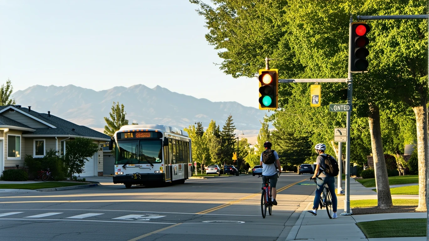
Public transit in Salt Lake City often centers around systems such as UTA (Utah Transit Authority), which operates rail and bus service across the metro. The presence of rail transit—a feature not found in many comparable cities—gives Salt Lake City a structural advantage for residents who live and work along served corridors.
Rail service connects downtown to key employment zones, the airport, and select suburban nodes. For commuters whose origins and destinations align with these lines, transit becomes a viable daily option. The system works best for single-destination trips during standard commute windows: downtown office workers, airport employees, and university commuters benefit most consistently.
Where transit falls short is in coverage breadth and off-peak service. Neighborhoods outside rail corridors rely on bus networks, which face the same challenges common to sprawling metros: longer travel times, indirect routing, and limited evening or weekend frequency. For households managing multiple stops—daycare, grocery, after-school activities—bus service rarely competes with the flexibility of a personal vehicle.
Transit also struggles in areas where pedestrian infrastructure is sparse. Even if a bus stop exists nearby, the walk to it may involve crossing wide arterials, navigating gaps in sidewalks, or covering distances that feel impractical with groceries or children. The system’s utility depends not just on route availability but on the walkability of the surrounding environment.
For renters considering transit-dependent living, proximity to rail stations becomes the key variable. Living within a half-mile of a station in a walkable neighborhood creates a fundamentally different transportation reality than living two miles away in a car-oriented subdivision, even if both are technically “served” by transit.
Driving & Car Dependence Reality
For most Salt Lake City households, driving remains the primary—and often only—practical option for daily life. The city’s development pattern, characterized by dispersed residential zones and commercial corridors designed around vehicle access, makes car ownership nearly essential outside core neighborhoods.
Parking availability reinforces this pattern. Most residential areas offer ample street or driveway parking, and commercial districts provide large surface lots. Unlike dense urban centers where parking scarcity discourages driving, Salt Lake City’s infrastructure assumes and accommodates vehicle use. This reduces friction for car owners but also means that non-drivers face isolation in many neighborhoods.
Commute flexibility favors drivers significantly. The average commute in Salt Lake City is 19 minutes, a figure that reflects relatively light congestion and direct highway access for many residents. For households managing complex schedules—multiple jobs, childcare, or irregular hours—the car provides control and predictability that transit cannot match.
Sprawl plays a defining role. As residential development extends into surrounding valleys and foothills, the distance between home and daily destinations grows. Grocery stores, schools, medical offices, and workplaces often sit miles apart, connected by roads rather than pedestrian paths. In these areas, even short errands require a vehicle, and the idea of a “car-free” lifestyle becomes functionally impossible.
The tradeoff for car-dependent households is exposure to fuel costs, maintenance, insurance, and the time cost of driving. But in neighborhoods where transit doesn’t serve daily needs, that exposure is unavoidable rather than optional.
Commuting Patterns & Daily Mobility
Commuting in Salt Lake City tends to follow one of two patterns: straightforward single-destination trips or complex multi-stop routines. The former benefits from the city’s relatively short average commute time and the availability of rail for corridor-based travel. The latter almost always requires a car.
Single-job commuters who live near rail lines and work downtown or along served corridors experience the most predictable transportation costs and routines. Their daily mobility involves walking to a station, riding rail, and walking to work—a pattern that eliminates fuel costs and reduces vehicle wear. For this group, proximity to transit infrastructure translates directly into lifestyle simplification.
Households managing multiple stops face a different reality. Dropping children at school, commuting to work, picking up groceries, and handling after-school activities creates a logistics puzzle that transit rarely solves. Even in walkable neighborhoods, the need to cover multiple dispersed locations within tight timeframes makes car ownership the default solution.
Work-from-home adoption in Salt Lake City remains relatively low at 3.5%, meaning most residents still commute regularly. This keeps transportation a central factor in household planning and monthly expenses, whether through transit passes, fuel, or vehicle costs.
Long commutes—defined as exceeding typical metro norms—affect 19.4% of workers. These households often live in outer suburbs or work in dispersed employment zones, facing longer drives and higher fuel exposure. For them, proximity to major highways becomes more important than proximity to transit.
Who Transit Works For — and Who It Doesn’t
Transit in Salt Lake City fits specific household profiles well and serves others poorly. Understanding which category you fall into determines whether car-free or car-light living is realistic.
Transit works best for:
- Downtown renters: Proximity to rail stations and walkable density makes daily errands and commuting manageable without a car. These households benefit from the city’s pedestrian infrastructure and transit coverage in core areas.
- Rail corridor residents: Living along served lines—whether in the city or select suburbs—creates access to predictable, direct transit for work trips. Single-destination commuters in these zones can rely on rail as their primary transportation mode.
- Cyclists in connected neighborhoods: Areas with notable bike infrastructure and mixed land use allow residents to handle short trips by bike and longer trips by rail or occasional rideshare. This works best for households without school-age children or complex logistics.
Transit struggles for:
- Peripheral suburban households: Neighborhoods beyond rail corridors lack the density and connectivity that make transit practical. Even where bus service exists, travel times and indirect routing make driving far more efficient.
- Multi-stop households: Families managing daycare, school, work, and activities face logistics that transit cannot accommodate. The flexibility and speed of a personal vehicle become non-negotiable.
- Off-corridor workers: Employment in dispersed zones—industrial parks, office campuses, retail centers—often sits outside transit coverage. Commuters to these locations depend on cars regardless of where they live.
The dividing line isn’t income or preference—it’s geography and routine complexity. Transit viability in Salt Lake City is a function of alignment: whether your home, work, and daily destinations fall within the infrastructure that supports non-car travel.
Transportation Tradeoffs in Salt Lake City
Choosing between transit reliance and car ownership in Salt Lake City involves tradeoffs in predictability, control, flexibility, and exposure to external costs.
Transit offers:
- Predictable routine costs: Monthly passes or per-trip fares create stable transportation expenses, insulating households from fuel price swings and vehicle maintenance surprises.
- Reduced vehicle burden: Households that rely on transit avoid or delay car ownership, eliminating insurance, registration, and depreciation costs.
- Simplified commutes: For single-destination trips along rail corridors, transit removes the need to navigate traffic, find parking, or manage vehicle upkeep.
Transit limits:
- Geographic flexibility: Living without a car restricts housing choices to transit-served neighborhoods, which may not align with affordability, school quality, or household preferences.
- Routine complexity: Multi-stop errands, irregular schedules, and off-peak travel become difficult or impossible without a vehicle.
- Time cost: Even on served routes, transit trips often take longer than driving, especially when transfers or waiting are involved.
Driving offers:
- Complete geographic access: Car ownership removes location constraints, allowing households to live in more affordable suburbs or access dispersed employment and services.
- Schedule control: Driving accommodates complex routines, last-minute changes, and off-peak travel without dependence on transit schedules.
- Household logistics: Families with children, elderly dependents, or multiple jobs find that cars provide the flexibility required to manage daily life.
Driving exposes households to:
- Fuel price volatility: Gas prices fluctuate, and longer commutes amplify exposure to those swings. At $2.77 per gallon, fuel costs remain moderate but not negligible for high-mileage households.
- Maintenance and depreciation: Vehicles require ongoing upkeep, and their value declines over time, creating costs that transit users avoid entirely.
- Parking and congestion: While Salt Lake City generally offers ample parking and light traffic, downtown and event-heavy areas still present friction for drivers.
The choice isn’t binary for many households. Car-light living—owning one vehicle instead of two, or using transit for commuting while keeping a car for errands—splits the difference, capturing some benefits of each mode while managing exposure to both.
FAQs About Transportation in Salt Lake City (2026)
Is public transit usable for daily commuting in Salt Lake City?
Yes, but only if your home and workplace align with rail corridors or well-served bus routes. Rail transit connects downtown, the airport, and select suburban nodes, making it viable for single-destination commuters in those zones. Outside these corridors, transit becomes less practical, and car dependence rises quickly.
Do most people in Salt Lake City rely on a car?
Most households depend on a car for daily life, especially outside core neighborhoods. The city’s dispersed development, low work-from-home rate, and limited transit coverage in peripheral areas make driving the default for errands, multi-stop trips, and off-corridor commutes. Transit works well in specific pockets but doesn’t serve the majority of residents comprehensively.
Which areas of Salt Lake City are easiest to live in without a car?
Neighborhoods near downtown and along rail corridors offer the best conditions for car-free or car-light living. These areas combine walkable infrastructure, transit access, and sufficient density of grocery stores, restaurants, and services. Living within a half-mile of a rail station in a pedestrian-friendly zone creates the most realistic non-car lifestyle.
How does commuting in Salt Lake City compare to nearby cities?
Salt Lake City’s average commute time of 19 minutes is relatively short, reflecting lighter congestion and direct highway access compared to larger metros. The presence of rail transit also distinguishes it from many comparable cities, offering corridor-based commuters an alternative to driving. However, sprawl and limited off-corridor transit coverage create car dependence similar to other Western metros.
Does Salt Lake City have good bike infrastructure?
Bike infrastructure in Salt Lake City is notable in certain areas, with a bike-to-road ratio that exceeds typical suburban norms. Cyclists in connected neighborhoods can use bike lanes and paths for short trips and errands. However, coverage remains uneven, and peripheral areas often lack safe cycling routes, limiting biking to specific zones rather than citywide viability.
How Transportation Fits Into the Cost of Living in Salt Lake City
Transportation in Salt Lake City isn’t just a line item—it’s a structural factor that shapes where money goes, where you can live, and how much time you spend managing daily logistics.
Households that align with transit corridors gain flexibility in housing choice and reduce exposure to vehicle costs. They can prioritize walkable neighborhoods, delay or avoid car ownership, and simplify commutes. This creates downstream savings in insurance, maintenance, and fuel, while also reducing the time cost of driving and parking.
Households that require cars—whether due to location, routine complexity, or employment geography—face ongoing exposure to fuel prices, vehicle upkeep, and the opportunity cost of time spent driving. These costs don’t appear as single large expenses but accumulate steadily, affecting how much remains for housing, savings, or discretionary spending.
The city’s relatively short average commute time and moderate gas prices soften the burden compared to larger metros, but they don’t eliminate it. For families managing multiple vehicles or long commutes, transportation becomes one of the primary cost drivers, second only to housing.
What matters most is alignment: whether your household’s daily needs, work location, and lifestyle preferences match the transportation infrastructure available in your neighborhood. Misalignment—living far from transit while trying to avoid a car, or living near rail while needing to make frequent dispersed trips—creates friction that affects both cost and quality of life.
Salt Lake City rewards intentional location decisions. Choosing where to live based on how you’ll actually move around each day, rather than on housing price alone, reduces long-term cost pressure and simplifies daily routines. The city’s mixed mobility pattern means that transportation outcomes vary widely by neighborhood, making proximity to the right infrastructure one of the most consequential financial and lifestyle decisions you’ll make here.
How this article was built: In addition to public economic data, this article incorporates location-based experiential signals derived from anonymized geographic patterns—such as access density, walkability, and land-use mix—to reflect how day-to-day living actually feels in Salt Lake City, UT.
—